Toll End Communication Canal Update - BCN
Cycling expedition
Update April 2010, Original post 25th October 2009
Update
Whilst there were quire a few structures to see at the eastern end of the Toll End Communication Canal, there was much less to see at the top end as it approached the New Main Line at Caggy's Boatyard.
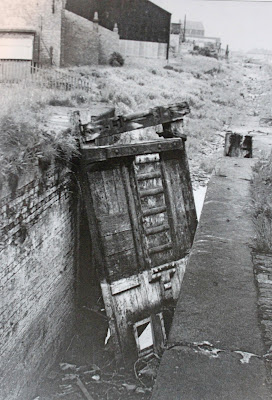
I was therefore rather pleased to find a 1970's photo of both Lock No2 and Moat Farm Bridge which sat immediately to the east of the railway.
Moat Farm Bridge over lock 5 on the Toll End Communication Canal
My search for obscure waterways draws me back to the Tipton area time and time again.
This is not because the area has any particular scenic beauty, far from it. In fact, much of it can best described as a post industrial wasteland, but nowhere else in the UK contains so many canals in such a small area. Of course, many of these waterways were abandoned in the middle of the last century but the desolate nature of the area means that, with a bit of poking around, telltale remains are still visible on the ground.
Tipton Green Branch Canal, middle lock chamber
The Toll End Communication Canal is a waterway with a confusing history, a hybrid never really knowing what it was. Soon after Brindley completed what we now refer to as the Old Main Line, a short 1/4 mile branch was dug to the east of Tipton Green in 1805, dropping down through three locks, known as the Tipton Green Branch. This initially terminated somewhere near the line of today's New Main Line at Watery Lane Junction. There is not a lot to see of this canal today, save the chamber of the middle lock which has been incorporated into a path.
The same scene as above in 1957
The following year the Tipton Green Branch was extended for a further mile, descending through four locks and following the line of what is now an open land drain to the side of Tipton Cemetry.
Toll End Branch Canal entrance from the Walsall Canal
Starting at the other end, a side arm of the Broadwaters Canal (now the Walsall Canal) was built in 1801, rising up through two locks to reach a new coal mine. Eight years later, in 1809, the Toll End Branch was extended westwards, linking into the mid point of the Tipton Green Branch, with the addition of two more locks. There is little to see of the Toll End section today, apart from a raised water pipe spanning an infilled entrance, and a bricked up archway under Toll End Road.
Rebuilt Brookhouse bridge
Further west the canal path can be detected passing under Bridge Road before it is completely lost under industrial wasteland, but continued on up the hill next to Tipton Cemetry, kinking round to the right to join the mid point of the older Tipton Green Branch. The line of this sharp twist is still visible from the air in the form of a stand of trees (just above Thursfield Road on the map).
Toll End Communication Canal bed from Bridge Road Tipton
The area between the eastern end of the Tipton Green Branch and the western end of the Toll End Branch became home to the Horsley Ironworks until 1865, which supplied many of the fine canal bridges we see in the area today.The recent construction of a new road to replace the old railway level crossing has revealed an archway in the embankment behind Caggy's yard, which was probably the canal bridge. Sadly, the construction team were not enthusiastic about my request for a hands on investigation, hence no photo!
The construction of the New Main Line in 1829 cut through the Tipton Green Branch creating Watery Lane Junction, which is now the site of Caggy's Boatyard.
So, this short 1 3/4 mile canal with its 9 locks was built in four stages over eight years to service the local mines and industry, until it was abandoned in 1966 and filled in in the 1970's.


Fascinating stuff, Andy.
ReplyDeleteHalfie,
ReplyDeleteI'm glad it is of interest.
I am in your neck of the woods this weekend, and planning to take a look at the Upper Bure (Aylsham) Navigation.
Watch this space!
Andy
Hi Captain
ReplyDeleteWhilst I know you're out and about on your trip to Crick (perhaps see you there!) I'm trying to find out as much as possible about the Toll End Communication Canal, as that's where our Eileen was built by Eli Aston in 1903. I wonder if you'd mind telling me what maps you used in tracing the route of the canal as I'm trying to locate something from around 1900 which might give a clue as to the location of 'Iron Boat Dock'
best wishes
Nick
Nick
ReplyDeleteMy preferred maps are the Godfrey Editions which are cleaned up versions of the 1902 / 1912 OS Maps. They are about 1.5 miles by 1.0 miles and provide amazing detail. I do have the map for Toll End - but of course I dont have it with me. Easy to get on the Internet but sometimes tricky to work out which sheets you need.
Andy
Hello,
ReplyDeleteThe picture captioned "Bottom Lock of Toll End Communication Canal" Looks suspiciously like the bottom two locks on the Bradley Locks Branch.