Tuesday, 29 November 2011

Shropshire Canals - book review

Shropshire Canals
A collection of articles from the Shropshire Magazine 1950 - 1965
Shropshire Libraries


This collected group of articles were published in 1980 covering the various canals in Shropshire.


Its an eclectic set of articles covering a lot of canals in very different  styles and therefore represents something of a lucky dip for a reader interested in the region's waterways.

The book kicks off with a series of ten walks by Lilian Hayward, conducted in the days when things busses and trains offered viable ways of getting back to the starting point. Her initial articles follow the Shrewsbury canal from end to end which I found fascinating, but then she switched to the Llangollen and Shropshire Union Canals which whilst interesting, didn't offer the same historical perspective as the abandoned canals.

Then E A Wislon picks up the tale with a more historically orientated set of accounts of the Ellesmere Canal, which again covers the Llangollen and its various arms. All good interesting stuff for historians.

A handful of random 'one off' articles are thrown in before the book really gets into its stride as far as I am concerned. There are four excellent articles about Telford's Tub Boat Canals by W Howard Williams, complete with accurate hand drawn maps, followed by a review of the non navigable Newport Junction Canal with a view to encouraging restoration by "Kiwi".

All in all this book offers a fascinating insight into the various canals of Shropshire as the existed over half a century ago. In themselves they seek to look backwards but in their telling they offer a contemporary insight into the state of the waterways in the 1950's and 60's and provide a reliable source of information for canal historians.

Sunday, 27 November 2011

Birmingham Heath Branch (Hockley Port)

Birmingham Heath Branch
(Hockley Port)
October 2011

Ask a group of BCN fans the whereabouts of Birmingham Heath Branch and you will find most are soon scratching their heads. 

Hockley Port 2011

The reality is that everyone knows it by its modern name of Hockley Port, an arm off the Winson Green loop which used to stretch for about half a mile. 


Map from Richard Chester- Browne's 'The Other 60 Miles'


These days it has been truncated just beyond the two fingers of the old Great Western Railway Interchange basins, but it both survives and is home to a sizeable residential community.


The arm was built in 1801 to Matthew Bolton's Soho Works, which made fine jewellery till it closed in 1863. 

Hockley Port interchange basin

Whilst the interchange section is in good repair, the line remains evident to Lodge Road where the bridge parapet, complete with blocked off fire doors, still stands. This means that the arm was in water to this point at least up till the second world war.


Beyond Lodge Road the line has been lost to new housing which fills the plot right up to the edge of the railway. The scale of redevelopment is such that not even the levels can be identified.

Lodge Road Bridge - with fire doors.

Well, that should be that - but it isn't. The maps show the canal continuing over a long gone railway aqueduct and into a basin at Soho Wharf. A quick drive round brings you to Wharf Street. The basin itself has been built over, but the canal still leaves its fingerprint on the area, even if is more by inference than hard remains.


Friday, 25 November 2011

Tercoo Rotating Blaster

Tercoo Rotating Blaster
November 2011

Wand'ring Bark is out of the water and undergoing her periodic bottom blacking. This time I have decided to have a go myself but my snag is in the preparation - how to do it?

Tercoo - straight out of the box

The previous boatyard blackings have involved a couple of coats of bitumastic after pressure washing, but no matter how clean it is the new coats don't seem to stick very well. My guess is that it needs taking back to the steel but grit blasting is costly and I wanted a DIY alternative. I considered all the options but none seemed to hit the spot - till I came across the Tercoo Rotating Blaster.

 Ready to go

This product is a rubber disc with 12 hard metal studs embedded in it. This fits in standard electric drill which runs at between 1500 and 3000 rpm (4000rpm max) and delivers a hammering action which strips off bitumen, paint, rust and body filler - taking it back to bare steel with a bit of practice.

Having pressure washed the hull, I wanted to clean off the rusty waterline. With this achieved it seemed sensible to strip off all the remaining bitumen so I set to with my two disc Tercoo blaster. I tackled a metre at a time, working down the hull in rhythmic sweeps and after a couple of hours I had the hull clean and with a good key for re coating. With a bit more effort its possible to bring it all to bright steel but that wasn't necessary on this occasion.

Two hours later - and one boat cleaned

The main thing is go gently and not to press too hard. The flat areas are ok but working into the corners and around the old anodes can be a problem. Its easy to slip and the studs get knocked off. By the time I finished I had lost about a third but it was still functioning and delivering the goods.

Close up of those lost teeth

Its a dirty job, and goggles and gloves are a must. Judging by the filth on my face I would suggest that a face mask would be a good idea too. 

This is an invaluable consumable item. Don't expect it to last much beyond a single boat stripping, mine dealt with a 42 footer before I worked into the corners and did  damage, but with care it would easily cover something much longer. My two disc model cost £40 plus £5 p&p but single and triple disc versions are available for the DIY market (£30 and £50 respectively).

Cleaned hull

The Dutch manufacturers claim its as good as sand blasting. I'm not sure it lives up to this claim but its probably the next best thing.

The Tercoo Rotating Blaster is available from Peter Coupland at Canal Cruisers .Com:

Wednesday, 23 November 2011

Lord Hay's Canal - part 3

Lord Hay's Canal - part 3
Newtown Bridge (Stafford Road) and beyond.
October 2011


The Stafford Road is very nearly the end of Lord Hay's Canal, nearly three miles after its junction with the Wyrley and Essington. 


Lake at Newtown - reservoir or subsidence?


After a long westward pull on the level it burrowed under the Stafford Road at Newtown Bridge before twisting to the north and finishing in a pair of parallel colliery basins.


Not surprisingly, the busy Stafford Road has been widened and flattened over the years and any trace of the original Newtown Bridge had been swept away but take a walk into the park opposite and its channel is immediately apparent. To the west is a large circular lake, either a reservoir or more likely the site of mining settlement and to the east of this is a wide saucer shaped trench the local kids use for their BMX bikes. 

Canal bed to the east of the lake

To the north of the park the canal is lost in piles of earth and drainage channels but knowing that more existed I cast around on each side. First I tried to the east near the road, walking through the grounds of an old folks home and could see some evidence of water in a trench behind the car park. With no obvious way down I returned to the park and explored the far side.

Lord Hay's Canal terminus behind the care home

To the west of the basins there is another lake and probably the site of another mine, but this one is well fenced in. With a bit of persistence I found a route in and bashed through the undergrowth into the bed of the basins. An old colliery wall is visible, supporting the care home's car park and the cutting to the north stretches on. I pressed on till the vegetation became too dense and I retreated with a rather unsatisfactory photo. Sadly there is now no good vantage point for the end of the Lord Hay's Canal. although the basins survive intact as far as I can tell.

Colliery Basins at the end of the Lord Hay's Canal - just add imagination!

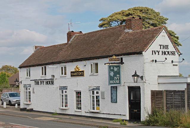
By now I had been on the move for four hours at three different sites, and all without a drink. Just opposite the canal terminus the Ivy House Inn stands ready to slake the thirst of parched boaters and it would seem rude not to sample a pint of Pedigree. I could have returned the way I had come, but I had been fortunate to pass through unchallenged so I opted to walk round, passing through the outskirts of Bloxwich and so returning to my car in Fishley Lane about 40 mins later.

Ivy House Inn - boaters rest.

Unusually, the thirty years which have elapsed since Richard Chester-Browne surveyed this route as part of his degree thesis have been kind to the Lord Hay's canal. The condition of the structures appears to be very similar and if anything, access is a little easier. I certainly found more beyond the Stafford Road than his review suggest is possible.


Not an easy canal to explore, but worth the effort.

Monday, 21 November 2011

Lord Hay's Canal - part 2

Lord Hay's Canal - part 2
Fishley No 2 Bridge to Newtown Bridge
Wyrley and Essington Canal
October 2011

We left the trail of the three mile Lord Hay's Canal at Fishley No 2 Bridge, just over half a mile into its course and soon after it became choked with rubble.

Looking west from Fishley No 3 Bridge

For a while the course is all but lost, the line marked out by a lonely winding hedge, with the land on the north side much lower than the south. Tucked in behind the hedge there are a pair of bee hives, their inhabitants alive in the autumn sunshine as they prepare for the onslaught of winter. I gave them a wide berth and set off on the southern side of the hedge taking care not to trudge over growing crops.

Infilled Fishley No 3 Bridge

After maybe quarter of a mile the stand of trees reasserts itself, marking out both the width and line of the abandoned cut. At the start it is quite possible to walk through the trees, following the exact line but then the vegetation thickens forcing you out into the meadows to the north. 


Fishley No3 Culvert

After dodging through a couple of gates I came across a track running over the canal, clearly the site of Fishley No 3 Bridge. I could see two parallel lines of bricks running across the track - indicating the top of the bridge supports. A bit of a scramble through the thicket and there it was, the bridge supports but with the parapets collapsed and the bricks loosely stacked in the old navigation channel.

West from Fishley No 3 Bridge

That wasn't all there was to this location. After casting round a bit I found a concrete cover with one section removed covering a brick lined overflow culvert. Ground water still oozes across its base and the remaining stump of the cast iron paddle sear sits lost and forlorn.

Looking east from Stafford Road

The undergrowth soon forces you out into the fields again so I continued along the northern edge of the track. Eventually, in the corner of the field, I found a gate which, after another barrier of brambles, took me to the site of Newton Bridge and Stafford Road - the end of this section.

Saturday, 19 November 2011

Reflections on Kazakhstan

Reflections on Kazakhstan
November 2011

I have just returned from a business trip to Almaty in Kazakhstan, my first visit to an ex Soviet Union country.


Mountains behind Almaty

Almaty is six hours ahead of us and in spite of being there for four nights, I never managed to overcome the jet lag issue. The trip was very successful but I am now on my knees with fatigue and trying desperately to stay awake to try and slot straight back into the UK sleep pattern. This is really important because we are moving the boat to Stafford boat club tomorrow, where it is being slipped and re blacked over the next week.

So what did I make of Kazakhstan? Well it has to be said that it is different, its people are warm and welcoming but as a non Russian speaker, communication is a complete nightmare.


Almaty

I was fortunate enough to spend a lot of time with a local who provided a fascinating insight into the city. In a nutshell, till the time of Stalin, Kazakhstan was a nation of about three million nomadic herders, devoid of any significant settlements. All that changed when Stalin decided to establish communities in the area, shipping in a broad assortment of ethnic minorities which has resulted in an unusual blend of races and a very tolerant population.


Rixos Hotel Almaty

Kazakhstan was the last country to leave the Soviet Union and you get the impression that they were not entirely unhappy with rule coming from Moscow. The city is therefore very young, laid out in a gridiron pattern, with long straight dual carriageways, just right for a speeding tank. Whilst the city has everything you need, it has no real centre and certainly no "old area". The traffic lights at the many intersections do come with a twist - the countdown boxes which tell you how long till the lights change. This results is a huge number of close calls among  drivers who are, how shall we put it? - somewhat competitive and embrace an automotive version of Russian Roulette as something of a national support.

I stayed at the Rixos, a posh up market hotel with prices which eclipse even those of London. This location necessitated a four mile commute to the office, most of which was in Gypsy Taxis. Now these need a bit of explanation - basically you stand by the road, stick your hand out and most times someone will stop, a price will be agreed and off you go. Hopefully, the car will be safe and the driver honest, but this informal approach to taxis appears to be a potential rapist's paradise.


Inside the Rixos

Kazakhstan is therefore a relatively new country and dosn't have a democratic constitution that we would recognise. It has been stable with just one president in office since independence, but as he ages and succession is unclear, clouds are gathering on the horizon. Logic says that the country has a bright future, with massive mineral potential and about 5% of the worlds undeveloped oil reserves. But the country needs stability to encourage inward investment to realise this potential - how many times have we seen dictatorships come to a destructive end.

The  city has a lot going for it, close proximity to lovely mountains and skiing, lakes and of course a lot of the great out doors - a country which is the size of Western Europe and only 15m inhabitants - mostly in Almaty and the new capital Astana. Almaty does have one other remarkable natural resource - the girls. Now don't get me wrong, I am a happily married man and no one can hold a candle to Belle's charms, but the Kazak girls are simple stunning, pettite, dark, slim, oriental with just a touch on Mongol - mix it all together, add a racy line of micro skirts and high heeled knee boots and the end result is remarkable. Not that I noticed of course....

Friday, 18 November 2011

Lord Hay's Canal - part 1

Lord Hay's Canal - part 1
Wyrley and Essington
October 2011

A physical walk of the Lord Hay's one mile canal of 1800 presents a bit of a challenge. The canal was privately owned during its working life and its line has reverted to private ownership following its closure in 1954, which means no public footpaths either along its length or crossing its path. So, if you want to take a look its going to be private land all the way, a veritable Mastermind walk - once you have started you have to finish, with no expedient get outs till you emerge at Stafford Road at the far end.

Lord Hay's Branch Canal - taken from Richard Chester Browne's "The Other 60 Miles".

But that's jumping ahead. Lets start at the beginning and follow this line methodically.To do this one justice will take three posts:

1. Wyrley and Essington junction to Fishley Bridge Number 2 - this post

Junction with the Wyrley and Essington Canal

The line starts with the junction at the Wyrley and Essington Canal, its splayed entry still plain with the first hundred yards completely infilled by BW who use the area as an official dredging site. Then its Fishley No1 Bridge which carries Fishley Lane over the line. The southern end is choked with rubble but the northern portal is visible among the undergrowth.

 Fishley No 1 Bridge

The line north is choked with brambles so if we are to make progress a detour is needed. My initial thought was to make use of the fairways of the adjacent Bloxwich Golf Club whose grounds border the first half mile. Such an approach would dictate a late evening sortie but this opportunity arose in late morning to I decided to probe the line from the fields to the north. Access to the start, the site of the old Fishley Colliery, is hampered by copious barbed wire but a couple of hundred yards up the road a public footpath provides a walk on route.  Don't bother to look for the Fishley Colliery basin. Where once there was an inlet there is now a mound of relocated spoil. 

Overgrown channel north of Bridge No 1

You catch glimpses of a bramble choked channel as you head north and then a fence forces you into the channel itself, a clear saucer shape indent sitting atop an earth embankment.


The clear channel beside Bloxwich Golf Club

This section represents a perfectly preserved canal track, remote and therefore devoid of the usual debris, not a lorry tyre in sight. This situation persists way beyond the Golf Club when suddenly you are faced with a huge pile of rubble. This point neatly illustrates the problem of canal hunting. Where you expect to find a depression you can so often end up standing on a mound!

Start of the rubble infill

From here the whole line has been used as a tip, this section filled in from the remains Fishley No 2 bridge, of which there is no sign. The site is still used as a dump with a farm track winding across the fields. This also marks the end of the broad canal track, with the course ploughed into the fields but its line marked by hedge.

Fishley Bridge 2 - site of an active tip

Thursday, 17 November 2011

Journal of a Voyage - book review

Journal of a Voyage
From Liverpool to Hobart Town and Sydney in the ship Othello in 1833 - 1834
by CM and NB Abbot
November 2011

A most unusual book, given to me by a friend who knows of my fascination for Watery Tales.


Its the verbatim journal of Thomas Mitchell, surgeon on Othello, a transport ship from Liverpool to Van Diemen's Land (Tasmania) which offers a brief day by day account of his journey which lasted over a year. From the off it was apparent that disease and death were constant companions and with little or no formal medical training the surgeon was in reality little more then a carer. 

Its an everyday tale of an extraordinary journey followed by thousands seeking out a better life on the other side of the world, in an age when life was cheap and emigration normally a one way ticket. The journal was never written to be read as a public document so you get a very gritty account of what happened, but very little insight into its author. A rare and fascinating perspective.

Just once, on 14th September 1834 and 13 months into the journey he open up a bit and we see a glimmer of the real man:

Fine day with more wind which is sending us homeward rapidly which makes everyone glad except myself who am as much or rather more at home here than in my native land. I certainly feel pleasure in seeing England, I can scarcely say home, for home I have none, pointed at and scorned by my relatives; but they never can persuade me to think myself the rascal they picture me; Tis' strange that none except themselves should think so but if God gives me health what need I care (it's bad enough now).

The authors strike me as amateur historians who stumbled over the original manuscript and became captivated by the subject, using the tale as a thread to research places and events along the way. By way of a counterpoint, they found correspondence relating to the Fenton's, an Irish family some of whom migrated on the Othello. The subsequent family history reveal what life was like for emigrants. 

This is therefore a book of two halves, a first rate journal at the front and a patchwork composite family history at the back. I am not convinced that the two sit very easily together but taken as a whole its insight is a unique gem, rare, unusual and one not to be missed.

One final and very personal twist comes in the provenance which brought this book to me.

As far as I can tell, the author died a few years after the voyage and the journal returned to his mother in Beverley, Yorkshire. It then stayed in Beverley till it was found for sale by the the father of the Abbot brothers, the authors and editors of this book. The journal than passed to the brothers who, in the 1980's, produced this volume. This particular copy was signed and given to John Bourne, a history professor at Birmingham University as a gesture of thanks for services rendered, who passed it on to my colleague Jim on his retirement as he cleared his shelves. Jim lives with my watery obsession and gave it to me to satisfy my interest in watery tales. If for no other reason, this known set of links sets this book apart from the ordinary.

Wednesday, 16 November 2011

Cape Arm - part 2

Cape Arm (southern section)
Birmingham Canal Navigations
October 2011

We left the Cape Arm with a northward look into the arm from Cranford Street Bridge.

Cape Arm south from Cranford Street

Cape Arm south from Cranford Street

So lets pick up the train looking south. One glance over the parapet of this 1906 bridge tells you that there is more to this arm than you would expect. The canal runs deep and wide behind the Thandi Coach depot before curling round under a huge concrete loading gantry, its roof gently slipping into the channel below.


GKN's loading gantry

The canal continues beyond this under a blue steel footbridge before coming to an abrupt end where a low level roadway crosses over. Whilst you cant see the next section, Google Earth suggests that  a short section remains in water on the other side leading to a residual element of a further arm which headed towards the Cape of Good Hope pub. I couldn't gain access to the site so there is no way of validating if this last bit still exists. Maybe one for another day.

Plaque on Cranford St Bridge

The loop used to continue on to the south, its path still visible as a roadway lined by old warehouses before petering out as it enters the only element of the site with operating businesses.

The final blue footbridge

The southern exit is obliterated but can be identified by following the line of the Winson Green Loop opposite and noting a slight change on the canal edging.

Line of the lost southern section

This arm offers a wealth of opportunity as and when the block is redeveloped. If it is used by industry this is probably the last we will see of it but if it is used for residential purposes the reopened canal would four a very attractive centre piece.

Who knows, one day we may be mooring our boats by the bar in Cape Square - but then again - maybe not!

Tuesday, 15 November 2011

Cape Arm - part 1

Cape Arm
Birmingham Canal Navigations
October 2011

Other posts in this series:

1. Cape Arm - northern section - this post
2. Cape Arm - southern section


Map from Richard Chester- Brown's 'The Other Sixty Miles'

Unless you are over 80 its highly unlikely you have ever navigated this stretch of the BCN, but the strange thing is that it is still in water, deep enough to float a narrowboat and to all intents and purposes there are no fixed obstacles preventing you accessing at least a bit of it.

Entrance to the Cape Arm from the New Main Line

But why the Cape Arm? I know lots of capes: Cape Horn, Cape of Good Hope, and Cape Wrath to name but three - but this one should be called the Cape of Frustration. Frustration because it is all in private land which, whilst abandoned, is boarded up as tight as a drum. As a result you have to catch glimpses of it from the few vantage points open to you. 

 The metal screen preventing access

Lets start with the history of the arm. It was originally part of the Brindley main line but the construction of the New Main Line in 1827 creatied a loop, one of a series coming out from Birmingham: Oozells, Winson Green, Cape and 'Avery'. The loop didn't last long as the southern end was soon filled in to prevent canny boatmen using the loop to get round the Winson Green Toll Stop. Thereafter the loop became an arm accessed via a tunnel under an embankment which carried a feeder from Titford to Rotton Park Reservoir.

The Rotton Park Reservoir feeder

Spool forward and the arm fell into disuse till GKN developed the site which surrounded it but traffic from the wider BCN ceased during the second world war and a guillotine gate was dropped across the entrance, limiting boat movements to a bit of internal work.

Today the northern entrance can be spotted from the cast iron bridge which used to span the entrance to Avery's Basin, alongside a second tunnel which used to lead to a basin but now contains the rotting remains of a cruiser which has been there for the best part of 30 years.

A glimpse over the wall

Getting sight of the arm as it extends into the works is a challenge in itself. The best view is obtained by climbing the embankment and peering over a razorwire topped wall which is protected by the now dry feeder channel. Even this vantage point calls for photography taken at arms length on tiptoe when a low footbridge can be seen spanning the water.

A sight of water over the north parapet of Cranford St Bridge

A reverse view can be caught over the parapet of Cranford St Bridge.

As far as I can tell, the passage under Cranford St Bridge may be blocked but the watercourse continues on - but more of that next time.