May 2016
Its frustrating when an area seems to change its name for no apparent reason. In all the old literature the next crossing is Moor's Bridge but for some reason it has changed to Straw's Bridge and this is the name given to the adjoining car park. So, if you pass under a sign saying Straw's Bridge near Kirk Hallam Community College you are in the right place.

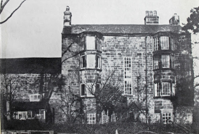


Bridge House - on site of Ladywood Road bridge
To catch up on our progress, we left the canal at Lock 4 (Birches Lock) and its nearby modern road crossing maybe half a mile downstream. Redevelopment has wiped the old Ladywood Road bridge away with Bridge House, the imposing toll house, being bought be the council in the early 1960's and demolished to improve the road layout. If it stood today I suspect it would have preservation order clapped on in in no time.
The next significant location is a decorative lake just to the south of the College. This lake incorporates part of the canal and lock 5 (Oxmeadow Lock) appears to have been sited somewhere in the lake.


Site of Oxmeadow Lake
Immediately adjacent to the college (Google Earth tells me its parallel to the middle of the football pitch) you will find Lock 6 (Sharb Pond Lock).There is no sight of the pond but the eastern wall of the old lock still stands in the trees, offering furtive cigarette smokers from the college somewhere to congregate away from teacher's eye.


Remains of Sharb Pond Lock (No 6)

Route of Hunloke's Arm (1950's)
Just before you reach Moor's Bridge (site of) Hunloke's arm exited to the West serving the ironworks and pits of West Hallam. Hunloke's interests in the canal were always minor and his shares were eventually sold and later he disposed of the rest of his estate to the Newdigates. Newdigate??? I can hear the cogs in your brain churning away - where have I heard that name before? Its the same Newdigate that owned the collieries and private Arbury network of canals and Griff Hollows Canal were built by him to connect his collieries between Bedworth and Nuneaton to the Coventry Canal in 1765. Its a small world.


Moors Bridge as it was - and as it is with Lock 7 (Straw's Lock) removed
The original Moor's Bridge has been swept away along with its adjoining canal cottages and Lock 7 (Straws Lock) but the canal path beneath the nearby railway remains. Upstream from Moor's Bridge there was a row of lime kilns (am essential ingredient in the Iron process) and Potters Coal Wharf. The area is still engaged in the iron industry but it is limited to Numbers 1 to 9 (plus the pitching and sand wedges) used by golfers on Pewt Golf Course.


Potters Coal Wharf to the north of Moor's Bridge
2 comments:
very nice posting, this series, with those beautiful & useful old pictures.
reading this put a smile on my face.
I am glad you are enjoying the account Frank - it was a pleasure to research.
Post a Comment