The continuing walk along the Cromford Canal
Ironville and Erewash Meadows
February 2010
We left the Cromford Canal mid way down the flight of which Ironville stands at the head.
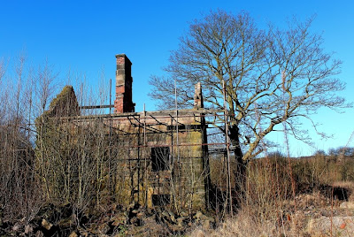
With the last lock chamber comes an abandoned lock keepers house, now reduced to a skeletal shell surrounded in rusting scaffold and with a chimney emerging from an non existant roof.
At the bottom of the locks there is what appears to be a winding hole, but a closer inspection reveals a lock width side arm with a bridge over the entrance. As the river backs onto this short stub I can only conclude that this was a dry dock / overflow which could be drained into the river. I may be wrong, but the signs certainly point in that direction.
View from the dry dock, Cromford Canal
There conclusion of the locks marks the end of the well maintained path which then circles back into the village through the playing fields. However, the towpath continues, narrower and wetter, but most certainly passable either on foot or on a bike. The canal is maintained at full depth along this section, cascading over a 12" waterfall mid way along, presumably installed to take account of subsidence in the area.
Erewash Meadow Nature Reserve
Eventually this attractive stretch comes to an end, passing under what was a substantial railway bridge and emerging into - nothing. Suddenly, in the middle of nowhere, the canal line vanishes under what is now referred to as Erewash Meadows nature reserve. The truth will almost certainly involve the old enemy, the coal mines. From here on the walley is pock marked with flashes, shallow lakes caused by the land subsiding into the old collapsing mines beneath.
But all is not lost, the actual line of the canal is clearly marked out with fences on either side, just waiting for the excavators to come along and dig out the ditch. More of that in a future post.
.


No comments:
Post a Comment