Oldbury Loop
The Oldbury Loop used to be a part of Brindley's original Mainline Canal. This was the extension or phase two which connected the first phase at Smethwick at the top of the Spon Lane Locks.
Brindley tended to follow the contours, thus avoiding expensive cuttings and embankments as far as possible, but this did make for a very winding route. The Oldbury Loop was bypassed as part of an early straightening programme in 1820 / 21, but the residual section of canal remained in use, providing access to the local industry and brickworks till the 1950’s.
There are surprisingly few ground level images of this old loop but a careful search through the archives of Britain from the Air offer a very comprehensive record of the line whilst it was still in operation, with some low level shots providing a startling level of detail.
The southern entrance was directly opposite the fan of Valencia wharves and the Churchbridge Branch, and the aerial views at this end are best located using the distinctive Bustle Bridge as a point of reference. The other end the canal was dominated by the extensive Oldbury Railway Interchange where good were moved on and off trains, making the final connection to their point of origin / destination by water.
We will explore this lost loop in a south to north direction, as of travelling from Birmingham to Tipton.
The Oldbury Loop from the air from over Titford Pump house
A closer view of Oldbury Loop
Entrance to Oldbury Loop (on left)
Oldbury Old Main Line 1949 - Frank Wakeman
Oldbury Loop southern entrance 1954 - Source Sandwell Archive RPS
Valencia Wharf and Entrance to Oldbury Loop - Worcestershire Archive
Southern entrance to the Oldbury Loop from the Churchbridge Branch
 Claytons Valentia Wharf (Vic Smallshire)
Allens Boatyard (Valencia) and into Oldbury Loop 1980 - David Harris
 Valencia Wharf from Whimsey Bridge
Whimsey Bridge from High Bridge
Oldbury Loop with Old Main Line crossing in foreground
Bustle Bridge on right
GWR Oldbury Branch Railway Bridge 1966 Ian Huselbee
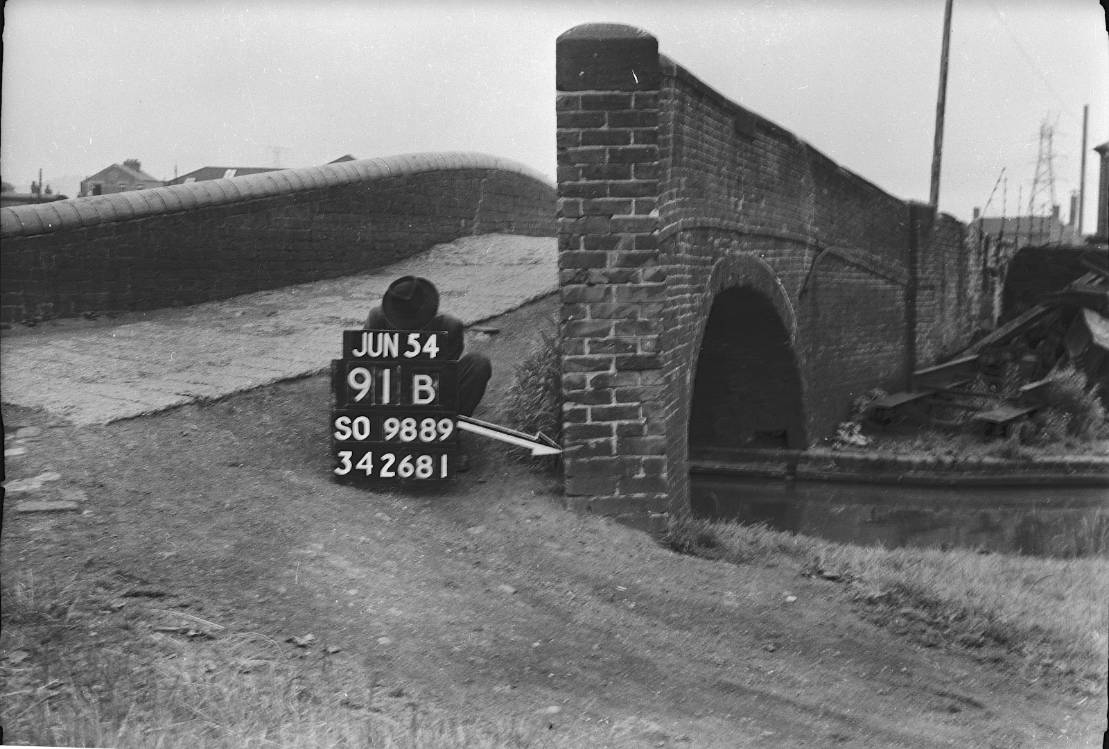
GWR Oldbury Branch Railway Bridge 1954 - Source Sandwell Archive RPS
Railway Bridge at the start of the Oldbury Loop 1965 - Ian Husselbee
Rail Bridge 1956 - S Higginbottom Worcestershire Archive
On GWR Oldbury Branch Bridge - Source Sandwell Archive RPS
Oldbury loop between Rail Bridge and Bustle Bridge 1956 - S Higginbottom Worcestershire Archive
Bustle Bridge (Centre)
Beyond Bustle Bridge
Bustle Bridge with water by David Morris
Bustle Bridge 1950 - Sandwell Archive (RPS)
Bustle Bridge 1965 - Ian Husselbee
Oldbury Loop and Bustle Bridge 1950 - Sandwell Archive (RPS)
Bustle Bridge in 1965 - Ian Husslebee

Bustle Bridge 1975 (Hugh Potter)
Bustle Bridge (carrying Birmingham Road)
Bustle Bridge 1975 (Keith Hodgkins)
Steps off Bustle Bridge 1950 - Sandwell Archive
Bustle Bridge 1956 - S Higginbottom Worcestershire Archive
Bustle Bridge - BCLM Archive
South face of Bustle Bridge in 1965 - Ian Husslebee
Bustle Bridge 1975 (Keith Hodgkins)
Bustle Bridge from the Laurence Hogg transparency collection
Oldbury Loop looking north from Bustle Bridge opposite Sawmills Source Sandwell Archive RPS
Looking South towards Bustle Bridge (RCHS)
Church Street 1969 Ian Huselbee
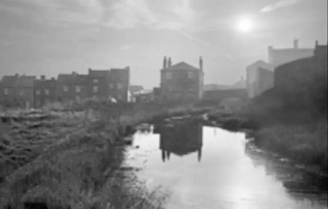
Postcard North of Bustle Bridge 1910 (David Morris)
 Bromford Road corner
View from under Bromford Road Bridge
 Bromford Road Bridge 1974 (Hugh Potter)
Bromford Road Bridge 1975 (Keith Hodgkins)
East of Bromford Lane 1949 - Frank Wakeman
Bromford Road Bridge - Arthur Farrand Radley BCNS Archive
Bromford Road Bridge - 1965 Ian Husslebee
Bromford Road Bridge looking west (RCHS)
 Bromford Road Bridge with adjacent Hunt Brothers basin
(entrance bridge demolished in 1945)
Bromford Road Bridge with adjacent Hunt Brothers basin
(entrance bridge demolished in 1945)
Oldbury Loop at West Bromwich St - David Morros
Approaching West Bromwich St Bridge (RCHS)
West Bromwich St Bridge and Canal Side from Bromford Road Bridge 1902
West Bromwich Street Bridge in 1965 - Ian Husslebee
Bromford Rd Bridge - John Thompson
Canalside from Bromford Road Bridge (the arch is artificial)
West Bromwich St Bridge looking north 1972 (Hugh Potter)
West Bromwich St Bridge Parapet 1975 Keith Hodgkins
 Parapet of West Bromwich Street Bridge 1975 (Hugh Potter)
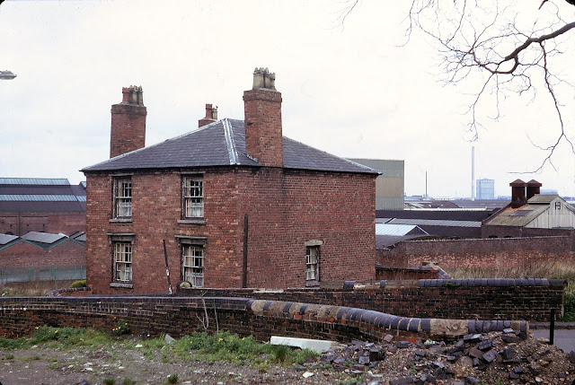
 House and Mission by West Bromwich St Bridge Oldbury 1975 (Hugh Potter)
West Bromwich St Bridge - Worcestershire Archive
West Bromwich St Bridge - Worcestershire Archive
West Bromwich St Bridge from Canalside 1950's David Morris
 Timber yards south west from West Bromwich St Bridge to Cocks Croft Bridge 1975 (Hugh Potter)
West Bromwich St Bridge to Cocks Croft Bridge - John Thompson
Same View in 1975 by Keith Hodgkins
Oldbury Boatyard to Cocks Croft Bridge
Oldbury Boatyard from the Laurence Hogg transparency collection
Boatyard to Cocks Croft Bridge - Ian Husselbee 1965
 Oldbury Boatyard 1975 to Cocks Croft Bridge
Cocks Croft Bridge (RCHS)
Cocks Croft Bridge 1965 Ian Husselbee
Close up of Cocks Croft Bridge in 1965 by Ian Husslebee
Cocks Croft Bridge 1956 - H Arnold Worcestershire Archive

 Cocks Croft or Freeth St Bridge 1975 (Hugh Potter)
Cocks Croft Bridge (Mark Priest)
Cocks Croft Bridge 1956 - H Arnold Worcestershire Archive
Oldbury Loop northern entrance - 1924 - The travelling crane spanning the canal from the boilerworks to the railway goods yard was built in the early 1920's
Opposite the Transhipment Basins in 1949 - Frank wakeman
Edwin Danks works on Oldbury Loop (RCHS)
Olbbury Boilerworks (Danks) 1954 Source Sandwell Archive RPS
Oldbury Boilerworks Wharf 1954 - Source Sandwell Archive RPS
Oldbury Boilerworks from Goods Station - Source Sandwell Archive RPS
T&S Elements Yard Oldbury with Danks Works behind (RCHS)


 Oldbury railway interchange 1913
Oldbury interchange yard in the early 1920's- BCNS Archive
Oldbury Interchange Basin 1956 - J Harrold Worcestershire Archive
Oldbury Goods Station 1954 - Source Sandwell Archive RPS
Northern Junction Bridge 1965 Ian Husselbee
Northern entry bridge to OML - Source Sandwell Archive RPS
 Canal scene at High Bridge on the new cut outside the Oldbury Loop
 High Bridge from the northern junction with the Oldbury Loop.
Wharf opposite northern entrance to Oldbury Loop - Source Sandwell Archive RPS
Oldbury Shortening - P E Gannon Worcestershire Archive
Works at High Bridge - Source Sandwell Archive RPS
Wharf opposite northern loop entrance - Source Sandwell Archive RPS
From wharf opposite northern loop entrance - Source Sandwell Archive RPS
Northern Entrance Bridge to Oldbury Loop 1956 - Source Sandwell Archive RPS
The above photos have been assembled from various sources, including those freely found on the internet. My thanks go to the many photographers alive and dead who have contributed to this collection and in so doing, are keeping the memory of these lost canals alive. These images are reproduced for ease of research are are not necessarily the property of this blog, and as such should not be used for commercial gain without the explicit permission of the owner (whoever that may be).


4 comments:
Hi Andy
I got a little confused with the one picture ( it says cocks croft bridge from bromford bridge ) but from my old maps, is'nt it west bromwich street bridge ?. i realy hope it is as it would be the best picture of the houses on the right which would have been canalside and where my dads family lived,the Bowens which i am trying to find.
thanks
Shane
You are quite correct Shane - I can remember where I found the image, but it is mislabelled. The configuration of houses places it as the section between Bromford Bridge Basin and West Brom St Bridge, running beside Canal Side. I have amended the label.
I used to live on McKean Road, not far from Bromford Bridge. I played there as a kid.
I used to live on McKean Road near Bromford Lane Bridge. I played there as a kid.
Post a Comment