The Tat Bank Branch was originally constructed as a feeder channel by Brindley to connect the Titford Pools to the old top level Mainline summit at Smethwick in 1769, but when that summit was lowered, the feeder was extended to supply Rotton Park Reservoir at Edgbaston.
Later on the first section of the feeder was opened out to navigable dimensions and a wharf built at the end, but it never carried much commercial traffic.


Tat Bank Branch 1934


The navigable extent of the Tat Bank Branch Canal


Zooming in (pumphuse in centre)


Tat Bank Branch 1964 - BIP on left, Tube Products on right with Allbright and Wilson in the distance


Taken from above the pumphouse


Feeder from the Tat Bank Branch to Rotton Park Reservoir - BCNS Archive

Tat Bank Branch Feeder Towards Mallin Street

Complex image with Tat Bank in foreground and Jim Crow, Chemical and Churchbridge Branches behind
 |
Tat Bank Branch Canal today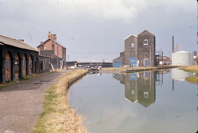   Not the Tat Bank Branch but just to the south covering the Langley Maltings area  GWR bridge over Titford Canal with Allbright and Wilson beyond         Unloading at Langley Green. Between the late 1920s and 1955, Thomas Clayton (Oldbury) Ltd held a contract to carry fuel oil from the Shell refineries at Stanlow, Ellesmere Port and to a lesser extent, Manchester to their depot at Langley Green near their base at Oldbury. The journey to the midlands is well documented and many photographs of boats engaged in this traffic have been published. However, there has been a dearth of pictures of the boats unloading at their destination. The accompanying photographs have been published locally in 'Making and moving in Langley' by Dr Terry Daniels of the Langley and Oldbury History Societies. . It is the first time we have seen them and acknowledge the Society for permission to publish them.. They were taken by F R Logan, from a Birmingham studio no longer extant. From the clothes of the boat people and the carefully polished brass chimney rings, it appears that the photographs were taken during the 1930s. The freshly tarred horse boat Erne has just finished unloading and the hatches are closed. The arrangement of the unloading gear can clearly be seen. In the second photograph, five horse boats, most with fore cabins, are queuing up waiting to unload. The unidentified boat being pumped out is nearly empty and has been tilted so that the last few gallons of cargo can be removed. Although the canal is deep to the edge opposite the unloading base, the boats further back cannot get right into the bank, making it difficult to for the crew to get off. However, unloading would have been fairly quick, so they wouldn’t have had to wait for long before unloading and winding to return down the six locks of the Titford Canal to the TC(O) yard to be prepared for the next trip. Little sign of the Shell depot remains now, but the fine buildings of the Langley Maltings in the background are still there.  |
The above photos have been assembled from various sources, including those freely found on the internet. My thanks go to the many photographers alive and dead who have contributed to this collection and in so doing, are keeping the memory of these lost canals alive. These images are reproduced for ease of research are are not necessarily the property of this blog, and as such should not be used for commercial gain without the explicit permission of the owner (whoever that may be).
4 comments:
Hi Andy
Does anyone know how far the Tat Bank Branch was navigable? There is a basin shown on the 1892-1914 Ordnance Survey 25 inch to the mile map available on the National Library of Scotland website (https://maps.nls.uk/geo/explore/#zoom=17&lat=52.49870&lon=-2.00469&layers=168&b=1). I'll call this the 1900 map.
The basin was on the eastern side, about 605 yards (556 m) from the junction with the Titford Main Line. The basin itself was about 80 yards (73 m) long, enough for three boats to tie up. This marks the minimum extent of the navigable length. On the 1900 map, the canal narrows to feeder width beyond the basin. However, the canal has since been widened to 30 feet (9 m) as far as Rood End Road Bridge. Indeed, the last section before the bridge is 50 feet (15 m) wide, suggesting there was a wharf there. Rood End Road Bridge is 945 yards (864 m) from the junction.
Fortunately, there is a later map on the same website, the 1949-70 OS 6 inch series, which I'll call the 1949 map (https://maps.nls.uk/geo/explore/#zoom=17&lat=52.49831&lon=-2.00525&layers=193&b=1). This marks a drain where the basin had been, but just beyond the basin is a railway swing bridge. This is strong evidence that boats must have navigated beyond the basin. Furthermore, the wider section is marked on the map and looks like it could have been a wharf for the adjacent Tube Works. However, there is no evidence of a winding hole on the 1949 map, so any boats would have had to capable of working from either end, or else be backed out. Perhaps someone from Liberty Tubular Solutions (current owners of the Tube Works), or a local, would know.
Steve
Steve - Navigation ceased at Rood End Lane / Road Bridge, just beyond Badgers Basin.
Beyond that the watercourse narrowed down to its original feeder dimensions. I cant see any sign of a winding hole near the bridge to my guess is that boats turned in the basin entrance.
The former railway swing bridge is still extant complete with pivot, wheels etc. and in use as a footbridge. The wide section beyond it would be navigable today if it were possible to reach it by narrowboat, it's at least 4ft deep.
I had a good look over the bridges and was surprised how much survives.
Post a Comment