Monday 30 May 2016

Nutbrook Canal - Shipley Reservoir

Nutbrook Canal - Shipley Reservoir and Paul's Arm
May 2016

Whilst we have reached the end of the line for the Nutbrook Canal its far from the end of the story. 

Shipley Reservoir dam

The Nutbrook was built is a relatively dry valley with a very limited catchment area for its water. The canal therefore started with its main reservoir at Shipley in the grounds of Shipley Hall, home of the Miller Mundy Family since the mid 1700's and a core promoter and backer for the waterway.

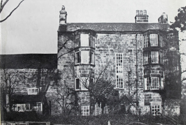
Shipley Hall 

Shipley Reservoir 2016

The valley in front the hall offered the only realistic site for a reservoir, and so a dam was built flooding the coach road and necessitating the construction of a bridge on the dam for access. This long sinuous lake must have represented a lovely water feature when full, but possibly offered a less aesthetic appearance when drained during the dry summer months!

Shipley Reservoir and associated canal

Today's lake bears little resemblance to the old reservoir with the upper end dried out on account of the reduced water levels (down about 6 feet) and widened to the east and the west due to mining subsidence. For many years the hall stood on a pillar of undisturbed coal but eventually one owned decided not to live there, the coal was excavated and predictably the hall suffered subsidence and was eventually demolished before 1940.

Its site remains on the west bank of today's lake but all traces have been erased by opencast mining and its later use as a theme park. Do you remember those signs to the American Adventure? This theme park opened in 1987 operated somewhat unexpectedly by Derbyshire County Council and initially was one of the country's premier tourist attractions before declining popularity saw it shut its gates in 2007.

The site is till owned by Derbyshire County Council and called Shipley Lakeside but essentially with the removal of all the theme park structures it has been left to its own devises with just the ghostly framework of the road system indicating a previous life.

Paul's Arm 2016

Whist the shape of the lake has evolved, the dam remains more or less as built with one of the bridges to Paul's Arm to the south still recognisible from the old Victorian photos, as does the rail link from the Woodside Mine at the northern end of the lake. Its winding gear and engine shed clinging on is the face of all the odds.


Remains of Woodside colliery


Colliery rail link to the canal then and now

Its strange how the oldest relics last the longest. Paul's Arm was an integral part of the reservoir as it accepted additional water from Mapperley Reservoir to the south and housed the sluice control to let water out into the adjacent canal basin.


Paul's Arm as it was - with the right hand arches of the bridge today

Canal feeder channel from Paul's Arm

Looking at this vast sheet of water its hard to see why the canal struggled to offer even nine lock fulls a day. However, I visited after a period of heavy rain and even them the flow down the valley was very small. The reservoirs may be big but there just wasn't enough coming in  from the small watershed to satisfy demand.

Saturday 28 May 2016

Nutbrook Canal - Pewt Golf Course to Mapperley Brook

Nutbrook Canal - Pewt Golf Course to Mapperley Brook
May 2016

The route north from Moor's bridge is aided by national cycleway 67, but I wouldn't suggest you bring your bike. On this occasion I was travelling with my NBF (New Best Friend) otherwise known as my Apple i-phone and I made full use of its GPS capability, draining out the battery in a single afternoon.

The thing is that whilst the cycleway closely follows the line of the canal, its not on the towing path which lies in the trees maybe 50 feet to the west. I had carefully transposed the canal route to a modern map using the Library of Scotland's excellent side by side map facility, the 1850 map faithfully tracing the route on its modern equivalent. This knowledge, coupled to the precision of the location finder on my phone gave me good warning of when I need to dive off the broad road (which the Good Book tells us leads to destruction) and onto the narrow route (which of course leads to salvation). 

This policy stood me in good stead when searching for the remains of Lock 8 (Pewit Lock), which I knew was located somewhere parallel to a large lake. The GPS suggested somewhere close to the southern end so into the undergrowth I bashed and nearly fell over the stone lock coping of the flooded lock. 


Pewit Lock (8)

I pressed on in search of Lock 9 Limekiln Lock following the line of a canal brimming with water. This led to a railway bridge which at first glace had two arches both of which were too narrow for a wide beam boat. However, this bridge was altered long after the canal was closed and closer inspection revealed the insertion of new brickwork. Remove the brickwork and you have a perfectly sized bridge hole.

Just beyond the bridge I climbed a narrow path finding myself on the edge of Limekiln Lock and uncannily standing in just the same place as Peter Stevenson was photographed back in 1966 (when I was five). 


Limekiln Lock (9) 1966 and 2016

The chamber is just as he saw it complete with gate recesses, groves for paddle gear, hinge stones and even wooden sealing strips. It may have been my imagination but I think that there are even metal remnants from the gate peeping out of the mud.


More of Limekiln Lock

North from Lock 9 the canal bed is pretty dry and reed filled to Hallam Wharf, site of a short arm linked to the local pits by a tramway. Just beyond the canal the Nutbrook also makes its first appearance, fed by mine water pumped from Woodside Pit in Shipley and subsequently filtered in settlement ponds which are on the line of the canal and cover lock 12 (Topside Nutbrook Lock) higher up the valley. This filtration system is to stop polluted water bubbling out of the Woodside mineshaft and polluting the ecology of the valley.


Iron Oxide from mine water

But we are jumping ahead. Just beyond Hallam Wharf the Mapperley Brook enters the canal and then there is the site of Mapperley Lock (Lock 10). The masonry has gone but the sound of water gushing over the descent is clearly audible in the undergrowth at the edge of the open country.


Site of the arm to Hallam Wharf


Nutbrook Canal above Limekiln Lock

From here we enter a large area of opencast mining which has obliterated the channel and all built structures. Lock 10 (Nutbrook Lock was just a few hundred yard further out on the opencast site whilst Topside Nutbrook lies beneath the settlement lagoons (see Google Earth for details). From there the canal made a beeline for the foot of the Shipley Dam passing under Parkers Bridge and through Top Lock (13) before entering the twin arms alongside Paul's Arm of the reservoir.


Overlooking Top Lock, terminus basin, collieries and old gasworks site.

Sadly you will have to take my word for the final three quarter of a mile which has departed this world leaving only a map entry to mark its passing.

Thursday 26 May 2016

Nutbrook Canal - Moor's (or Straw's) Bridge area

Nutbrook canal - Moor's (or Straw's) Bridge Area
May 2016


Its frustrating when an area seems to change its name for no apparent reason. In all the old literature the next crossing is Moor's Bridge but for some reason it has changed to Straw's Bridge and this is the name given to the adjoining car park. So, if you pass under a sign saying Straw's Bridge near Kirk Hallam Community College you are in the right place.


Bridge House - on site of Ladywood Road bridge

To catch up on our progress, we left the canal at Lock 4 (Birches Lock) and its nearby modern road crossing maybe half a mile downstream. Redevelopment has wiped the old Ladywood Road bridge away with Bridge House, the imposing toll house, being bought be the council in the early 1960's and demolished to improve the road layout. If it stood today I suspect it would have preservation order clapped on in in no time.

The next significant location is a decorative lake just to the south of the College. This lake incorporates part of the canal and lock 5 (Oxmeadow Lock) appears to have been sited somewhere in the lake.


Site of Oxmeadow Lake

Immediately adjacent to the college (Google Earth tells me its parallel to the middle of the football pitch) you will find Lock 6 (Sharb Pond Lock).There is no sight of the pond but the eastern wall of the old lock still stands in the trees, offering furtive cigarette smokers from the college somewhere to congregate away from teacher's eye.


Remains of Sharb Pond Lock (No 6)


Route of Hunloke's Arm (1950's)

Just before you reach Moor's Bridge (site of) Hunloke's arm exited to the West serving the ironworks and pits of West Hallam. Hunloke's interests in the canal were always minor and his shares were eventually sold and later he disposed of the rest of his estate to the Newdigates. Newdigate??? I can hear the cogs in your brain churning away - where have I heard that name before? Its the same Newdigate that owned the collieries and private Arbury network of canals and Griff Hollows Canal were built by him to connect his collieries between Bedworth and Nuneaton to the Coventry Canal in 1765. Its a small world.


Moors Bridge as it was - and as it is with Lock 7 (Straw's Lock) removed

The original Moor's Bridge has been swept away along with its adjoining canal cottages and Lock 7 (Straws Lock) but the canal path beneath the nearby railway remains. Upstream from Moor's Bridge there was a row of lime kilns (am essential ingredient in the Iron process) and Potters Coal Wharf. The area is still engaged in the iron industry but it is limited to Numbers 1 to 9 (plus the pitching and sand wedges) used by golfers on Pewt Golf Course.


Potters Coal Wharf to the north of Moor's Bridge

Tuesday 24 May 2016

Nutbrook Canal - Stanton Ironworks to Birches Lock (4)

Nutbrook Canal - Stanton Ironworks to Birches Lock (4)
May 2016

After the desolation of the Ironworks site we now break free into the relative tranquility of the countryside. I say relative because a crushing plant sits alongside the canal and its crashing and grinding can be felt as much heard.

Ilkeston Road Bridge from the north

But from a photographic perspective it all suddenly gets very lovely. The next two pounds through Lock 3 (Old Furnace Lock) to Lock 4 (Birches Lock) are maintained by the local angling club alongside a lake created by recent opencast mining and very pretty it is too. 

Looking north from Ilkeston Road

The Ilkeston road crosses the canal more or less on the level. Just south of the bridge is the old Stanton Basin (the lake beyond will be another area of opencast or subsidence). During its last days the canal was kept navigable to the basin to allow boats to turn and exit the canal to the Erewash.

Stanton Basin is to the right behind the fisherman

Old Furnace Lock is something of a delight because we have images of it, already with a weir at the top end from 1956 at which time the same valve gear existed but the fields to one side have been replaced by a big lake.


Old Furnace Lock in 1956 (B&W) and 2016

Just above Lock three Stanhope's Arm exited to the west. It was never very long and whilst the outline can be seen, its bed is so choked up it is possible to walk across it and barely get your feet wet.

Stanhope's Arm

The canal is then crossed by a narrow brick bridge which has had its middle section replaced with a flat concrete slab. It appears to be a pedestrian bridge built to connect the two communities of Hallam. 


Pedestrian Bridge between Little Hallam and West Hallam

From there its a short walk up a steadily silting and overgrown channel to the rubbish filled chamber of Lock 4 ( Birches Lock) which can be found immediately to the rear of the houses on Valley View.


Lock 4's debris filled chamber

Sunday 22 May 2016

Nutbrook Canal - Stanton Ironworks

Nutbrook Canal - Stanton Ironworks
May 2016

Stanton Ironworks and the Nutbrook canal were inextricably linked from the outset, the canal feeding the ironworks with its raw materials of coal, ironstone, limestone and water. The works also stood on its junction with the Erewash Canal which offered further supplies of raw materials from the Pinxton area and of course a route for the heavy end product to reach its market.

Stanton Ironworks and canal 1865

In the end the Iron works came to own the canal when no one else wanted it, and even then it was needed just for the last mile or so for in site movements and more crucially, for the cooling water it needed in its processes. In the end the canal was no longer needed and was culverted under what became a slag crushing site with the slag being used for hardcore in road building. 

Stanton Ironworks site 2016

The scale of the Stanton Ironworks site is vast and continued in production till the 1980's following a series of nationalisations and privatisations, but caught by a severe downturn the 7,000 staff were laid off and the plant levelled to the ground. Today it is just a windswept concrete pad littered with lumps of iron slag awaiting its next incarnation, which is planned to be 1,900 homes - 30 % of Ilekston's housing needs for the next 20 years. You do have to wonder if this huge development wouldn't benefit from a nice water feature including a lock or two. Waterside homes always carry a premium.


And so today we are left  with some fading images of an long dead industrial past, and here and there some telltale clues of the canal which facilitated its growth and prosperity for over a century.


Lock 1 - Black Saddle Lock 1956 with boats loading in 1937 and 1944.

The last section of canal to close was the bit beneath Lock One (Black Saddle Lock) site of the  loading wharf which saw slag sent south to build runways during the war and shell casings for the military.

Lock Houses 1961

Black Saddle Lock and Lock 2 (Stanton Lock) were both filled in in 1956, a decade after trade had ceased.

Lock 2 - Stanton before it was in filled in 1956

Today just a reeded trough can be found crossing the middle of the bleak site before the canal breaks free at the northern boundary - site of the cooling water outlet and some very unpleasant looking sediment.


Canal channel above Lock 2 on the Stanton site plus the cooling outfall.

But fear not - the rest of the canal is nothing like this. The post industrial apocalypse comes to an abrupt end and something approaching beauty takes its place.

Looking north from the edge of the Stanton site