Showing posts with label Tub Boat Canals. Show all posts

Sunday, 1 April 2012

Shropshire Canal - Coalport

Shropshire Canal
Coalport
April 2012

April 1st, and my last post in the Shropshire Tub Boat Canal series! Hurray I hear you all cry - enough pictures of overgrown ditches - lets have some more of your "nice" canal photos...

Restored canal at foot on Hay Incline

Well, by the time you read this we will be on our way to Llangollen so its back to the summer boating routine. However, this series has been six months on the making, three planning and assembling the maps and three doing the field work / write ups. At least its kept me off the streets for the winter.

Past the China Museum

The Coalport section of the Shropshire Canal offers a final hurragh for the canal hunter. The section at the bottom of the Incline was put back into water in the 1970's and this section runs into the China Museum site, all very pretty.


The canal line buried beneath the access road

Beyond that the line of the canal has been lost in a housing development built on the site of NuWay, but the line of the canal is followed by the access road. From there the canal runs behind the Brewers Arms Inn and reemerges as a dry ditch which runs parallel to the River Severn to Coalport Bridge.

The dry ditch approaching Coalport Bridge

This low level canal avoided the fast flowing section of river and craft initially accessed the river at Coalport Bridge via a short lived lock. This was later replaced by a self acting lift where goods were transhipped into larger river worthy trows.


 Journeys end - Coalport Bridge

Phew..............

Friday, 30 March 2012

Shropshire Canal - Hay Inclined Plane

Shropshire Canal
Hay Inclined Plane
March 2012
 
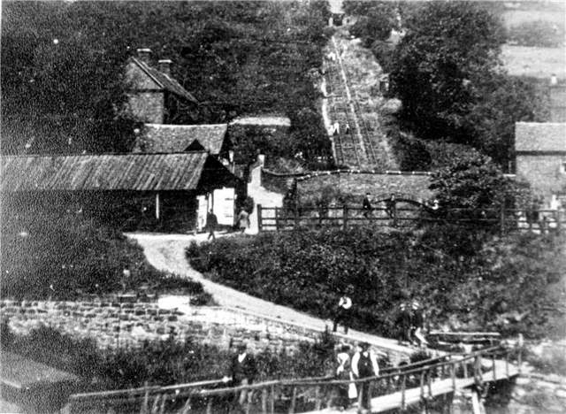
The Hay Inclined plane at Coalport offers the best insight into how these structures worked. 

Hay Inclined Plane from Coalport

This plane was initially self acting, which is to say that it worked under gravity with heavy loads going down pulling empty tub boats back up. When the balance was reversed a horse drawn winch was used from 1791 to 1793, but a steam engine was installed in 1793 and this delivered a good service during the plane's working life which ended in 1894.

 Looking up and down the Hay Incline Plane - BR's steepest gradient!


The plane replaced the equivalent of 27 locks with four men able to raise a five ton load 207 feet in three and a half minutes.

In keeping with the other inclines on the Shropshire Canal system, the tub boats were initially settled onto wheeled bogies which were hauled over a low "hump" at the top of the incline before being let down its twin tracks, passing an ascending tub half way.

Top of Hay Inclined Plane, Blist Hill Museum

There are accounts of cables snapping and five ton loads hurtling down the incline and careering right over moored boats and ending up in the middle of the River Severn. 

The incline you see today is a reconstruction of the 1970's, created as part of the Blist Hill Living Museum, with ex British Rail tracks laid to provide a visual idea if how things looked during its operation. In actual fact an L shaped plateway track was used but hey, its good enough.


Archive images of the Hay Incline:

 1957

 1879

Source - Ironbridge Museum Archive


 1958

 1971

Operational Incline with  Jacksville Ferry


Severn Trow at Ironbridge


A rebuilt Spry in 1986 - Source - Ironbridge Gorge Museum Archive

The above photos have been assembled from various sources, including those freely found on the internet. My thanks go to the many photographers alive and dead who have contributed to this collection and in so doing, are keeping the memory of these  canals alive. These images are reproduced for ease of research are are not necessarily the property of this blog and some may still be subject to copyright, and as such they should not be used for commercial gain without the explicit permission of the owner (whoever that may be). 

Wednesday, 28 March 2012

Shropshire Canal - Blist Hill

Shropshire Canal
Blist Hill
March 2012

The Blist Hill section of the canal comes as something of a revelation. It represents the last section to be used in the south with coal being delivered from the collieries near Tweedale until 1912 after which it fell into dereliction. The rebirth of the Blist Hill site into a living museum included the reinstatement of of the Shropshire canal which ran through it. 

Blist Hill Wharf


This means that the canal can be seen in its operating state, complete with wharf's cranes and even a single iron tub boat, he last of its kind. The section nearest the museum operates at full depth but the later stages towards the top of the Hay incline have reduced or no water in them. This stretch was always prone to leakage and slippage so its not surprising that it isn't kept full.


The last tub boat

There are regular narrows, built to contain stop planks in the event of a breach. All very atmospheric and educational.


For the purposes of this visit I skipped the museum and skirted round the back of the site, following a narrow path to the incline which offered some good views of the canal which I have interspersed with images taken within the museum when we visited last spring.

Archive images of canal at Blist Hill

Shropshire Canal at Blist Hill between 1900 and 1920 including the pit head

Refloating the last Lilleshall Co's Iron Tub Boat 749 after repair in 1972 - Source Ironbridge Museum Archive


The above photos have been assembled from various sources, including those freely found on the internet. My thanks go to the many photographers alive and dead who have contributed to this collection and in so doing, are keeping the memory of these  canals alive. These images are reproduced for ease of research are are not necessarily the property of this blog and some may still be subject to copyright, and as such they should not be used for commercial gain without the explicit permission of the owner (whoever that may be). 

Monday, 26 March 2012

Shropshire Canal South - Madeley

Shropshire Canal South
Windmill Incline to Madeley
March 2012


Other posts in this series:


1. Windmill Incline to Madeley (this post)
2. Blist Hill
3. Hay Inclined Plane
4. Coalport

Returning to the Horsehay Branch near Aqueduct the remains of the canal track are few and far between and the best you can do is to try and follow the contours. Even this limited objective is complicated in the area called Brookside (yes, it actually looks like TV's Brookside) which has built up on the site of the old Windmill Inclined Plane. The area was the site of a huge coal mine and the whole area seems to have been used as a tailings dump. 


Even in 1902 the traces of the canal were fragments and the line could only be deduced by inference. As far as I can tell, the top of the incline is near the south side of Windmill School and descended just 125 ft in 600 yards so it was a long and gradual descent from the school, through the dual carriageway and on into Tweedale and having its base around the entrance to the Severn Gorge Caravan Park and the Cuckoo Oak Pub before crossing the Bridgnorth Road and through the Tweedale Industrial Estate.


Bottom of Windmill Incline crossing the Bridgnorth Road


Through Tweedale industrial Estate


and out along a strip of old towpath to Prince Street


Although no traces of canal remain in this area, its line can be followed as a public path on a strip of wild ground between Tweedale Industrial Estate and Prince Street before crossing Kemberton Road / Queens St and probably running down the eastern side of a railway embankment which follows a similar southerly course.


Course of canal emerged from these trees in Madeley


Shropshire Canal bed in Madeley

Getting wetter...

and wider...

End of canal at Blist Hill

The track is indistinct on the ground but the maps are clears that it ran south into Madeley. This popular park is criss crossed with cycle ways and the canal re emerges next to Sutton Way, first as an intermittent dry ditch, and then increasingly in water as we approach Blist Hill and the site of the Madeley Brick and Tile Works which is now the museum overflow car park.


Through the museum overflow car park.

Tub Boats on Shropshire Canal at Tweedale with Madley Furnaces behind  - Source Ironbridge Museum Archive


The above photos have been assembled from various sources, including those freely found on the internet. My thanks go to the many photographers alive and dead who have contributed to this collection and in so doing, are keeping the memory of these  canals alive. These images are reproduced for ease of research are are not necessarily the property of this blog and some may still be subject to copyright, and as such they should not be used for commercial gain without the explicit permission of the owner (whoever that may be). 

Saturday, 24 March 2012

Shropshire Canal - Brierly Hill Incline

Shropshire Canal
Horsehay Branch - Brierly Hill Incline
March 2012

In some ways this post is about an incline that isn't. 

Brierly Hill Incline

Confused? Well I am referring to the inclined plane at the end of the Horsehay Branch which provided access to Abraham Derby's Coalbrookdale Ironworks. Strictly speaking it isn't part of the canal network as it carried one ton loads which had already been transshipped from the tub boats rather than a plane which carried the boats themselves. I therefore don't count it as one of the six tub boat inclined planes of the Shropshire Canal network, but the whole transshipment set up was very unusual and deserves a post of its own.


The remains of the westernmost loading bay

Lets start with Charles Boyce without whom the Horsehay Branch series would have ended with my last post. Charles owns Old Wynd, the building which appears to have formed part of the site from its industrial days 200 years ago, plus the garden and woodland which make up the overall site. Not only is he the landowner but he is also a passionate historian about the incline, and an avid boater - a pretty compelling mix!

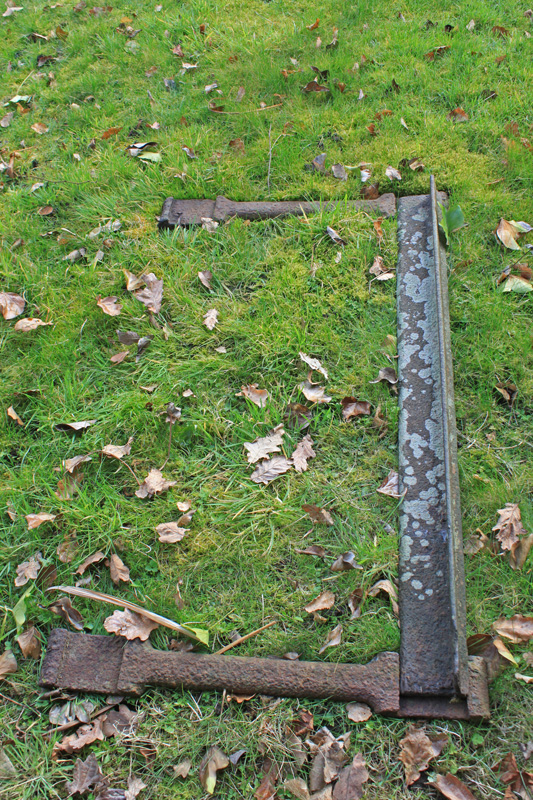
 Remains of the plateway recovered from the site.


Having bought the site years ago he became aware of the features it contained and, armed with a JCB, proceeded to excavate large areas in search of artifacts - a one man time team if you like! Bit by bit he unearthed the story till he had built a probable sequence of events which he generously shared with me.

 Views of the incline - from the top and the bottom.


My history lite version of events is as follows:

The terminus would have been built in or around 1792, at a reputed cost of £2,000, which was more than a small fortune at the time. So, why so expensive?

Well, it is known that before the inclined plane was built, the connection to the factories of Coalbrookdale were reached via two ten foot diameter vertical shafts which descended into a lateral tunnel 120 feet below. 

Images from Reynolds note book show four loading bays into which sub boats were maneuvered and from which loads were taken and let down one of the shafts, with the same rope lifting an empty carrier up the other one, all operated by gravity. From the bottom of the shafts the goods would have been wheeled out and away, quite possibly to the flat area near the reservoir which was probably created from the spoil excavated in the tunnel's creation. The presence of the shafts has been proven by Charles but the whereabouts of the tunnel entrance is pure conjecture.


Innovative as this arrangement was, it does not seem to have been entirely successful and alternative mechanisms were considered but, as was the case at Lilleshall, it was eventually abandoned in favour of an Inclined Plane. Ok so far, but the twist is that the documentary evidence suggests that at least for a time the shafts and the incline operated simultaneously. The evidence on the ground support this idea but its not obvious at first glance.

The shaft into the tunnel

For a start all inclines need to be at a constant gradient,  but the route down the hill has a kink, descending at 15 degrees lower down but only 9 degrees at the top end. The assumption, confirmed by the old maps, is that the incline was on the lower section and that a tramway led down the shallower gradient at the top. So how did a tram get past the congested lifts site which stood like a sheer cliff as the top of the slope? Answer - through the tunnel found buried 20ft below Charles garden. The cargoes would have been unloaded at the newer Old Wynd Cottage and then wheeled under the canal basin via the tunnel, and on down the hill to the top of the incline. Again, this is all conjecture but the story seems to fit the facts.

Charles descending into the pit

The canal itself was short lived, with the Coalbrookdale end abandoned by 1802, less than 10 years after its construction, by which time a tramway had been built along its towpath. The rest of the Horsehay Arm was soon to follow and was fully abandoned by 1825. Therefore, the remains we see today are nearly 200 years old and reflect a canal which, in part, worked for less than a decade.

The tunnel beneath the garden

In its last incarnation the canal had been removed and instead of taking the tramway through a small tunnel, the tub boat docks and part of one of the shafts were removed to allow the tramway to pass right through the middle of the site, destroying much of the built remains in the process.

Charles - we ran through all the history at quite a lick - did I get it about right? 
Many thanks for the tour.