Thursday 31 October 2019

Union Arm and Izon Old Turn BCN

Union Arm, BCN

The Union Arm is an elusive little canal, a twisting arm which came off the original Birmingham Canal near what became Pudding Green Junction. 

Its course was complicated when the New Main Line was built in the 1840's, cutting across its line with both its start and terminus on the eastern side but the meat of the waterway on the west.

The little network of canals and basins are long gone, but I recently found a photograph in the Hugh Potter collection taken in the early 1970's which shows the entrance the the end basin, and the factory backdrop still exists providing an accurate location.

If I find any more images of the Union Arm I will add them to the post.


Northern entrance to the Union Branch taken where the New Main Line crossed its path (Hugh Potter)

Duncan Moore did some more research on this elusive waterway and found a set of aerial shots which capture much of this Branch:

Entrance to Union Branch in context of Pudding Green Junction

Looking into the Union Branch (left) in 1951 with the Albion Interchange in the centre

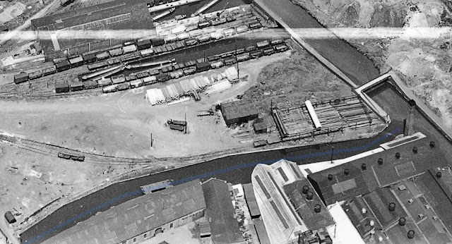
Entrance to Union Branch from the Wednesbury Old Canal with Albion Railway interchange at the top taken in 1951

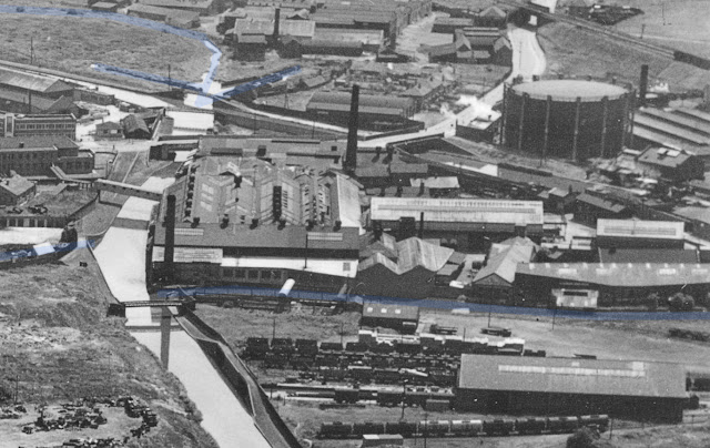
Midway down the Union Branch in 1951
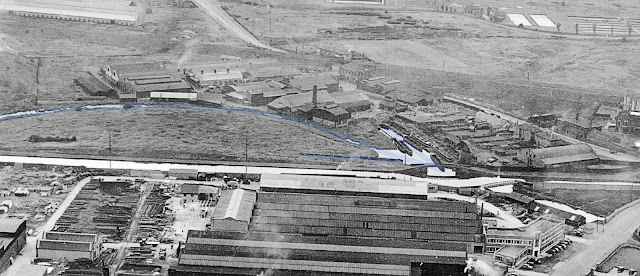
Far end of the Union Arm in 1951

Another view of the original terminus in 1934 (see map below)


Izon Old Turn

There is a risk of disappearing down ever smaller rabbit holes when it comes to tracking down the lost sections of the BCN. So, rather that create a new post and given its proximity to the Union Branch, let's include the Izon Old Turn here.

Just as the Union Branch ended up straddling the New Main Line canal, the construction of the New Main Line also created a loop canal which used to be part of Brindley's original Birmingham Canal as it curved inti what became the Wednesbury Old Canal at Pudding Junction. Not that there were any junctions here in Brindley's day!

Izon Old Turn can be seen at the top left, continuing across Pudding Green Junction

Izon Old Turn complete in 1951

This 1948 image shows most of the loop with a boatyard at Pudding Green

Looking back from Izon Old Turn from above the boatyard in 1948


Click here to return to the Birmingham to Smethwick index page

The above photos have been assembled from various sources, including those freely found on the internet. My thanks go to the many photographers alive and dead who have contributed to this collection and in so doing, are keeping the memory of these lost canals alive. These images are reproduced for ease of research are are not necessarily the property of this blog, and as such should not be used for commercial gain without the explicit permission of the owner (whoever that may be).

Wednesday 30 October 2019

Hednesford photos on the Cannock Extension Canal

Hednesford Basin, Cannock Extension Canal
October 2019

Exploring the northern extremities of the BCN represents something of a challenge.

The problem is the Cannock coalfields they were built to serve. The most northerly tendril of the BCN empire was the Cannock Extension Canal, a thin ribbon of water which extended north from Pelsall Common and ended at a basin in Hednesford, near Cannock.

Today just over a mile of the Cannock Extension exists, terminating abruptly at the A5 trunk road. With a bit of perseverance it's possible to track its course for another mile or so north to the site of Conduit Colliery, but there the trail goes cold. 

When traditional coal mining was over the NCB decided to open cast the area, which essentially means scraping off all the surface layers and exposing the remaining coal measures to the open air, and the onslaught of bulldozers. All very efficient but a nightmare for the canals. They were already subsiding into the underground mines, but now they were swept away in their entirety. When Humpty Dumpy was put back together again the re-profiling was nothing like it was previously, and not only are the lines of the canals gone, the land is now markedly lower.

Fortunately, Hugh Potter, a keen canal enthusiast, spent time in the area in the early 1970s and took some cracking photos just before the remaining structures were lost forever.

The following are some images of the Hednesford end of the canal.

BCN cottages at Hednesford Basin, Cannock Extension Canal

Last Bridge on the Cannock Extension Canal at Hednesford

Stable block at Hednesford, BCN


The original blog post for this section is linked here.


Tuesday 29 October 2019

Halford Branch Canal

The Halford and Jesson Branch Canals

OK BCN enthusiasts, you are in for a bit of a treat. 

This remote fragment of the lost BCN proved elusive for many years but Hugh Potter has very kindly given me access to his extensive collection of black and white photos taken around the BCN in the early 1970s. Then, like busses - a whole collection of archive images crop up and hey presto we have photos of the entire line except the ultimate terminus beyond Halford Bridge.


It has been an absolute delight to work through the images, adding dates and places to the scanned images plus sorting them into my slightly idiosyncratic sub divisions of the BCN.

Among the wealth of images which show the BCN as I first encountered it in the early 1970's, there are some absolute gems which show built remains on some of the "other 60 miles' and represent the very first ground level photos I have found of these lost miles, and in particular there are a couple of images from the elusive Halford Branch near West Bromwich.

For some reason this particular area of the BCN has been particularly well covered by aerial photographs, so it is possible to cover every angle of this backwater. The area has been totally transformed in the 70 years since these aerial photographs were taken, so this intense focus on a small area gives good sense of how the Black Country looked. You can almost smell the smoke from all those chimneys!

The entire Halford Branch Canal seen from above the Ridgacre Branch

The junction of the Halford Branch with the Ridgacre Branch

BCN Tug entering the Halford Branch in 1948

A wider view of the same panorama

Halford Junction with Davies Colliery Bridge at bottom left

The end of the Ridgacre Branch and the entrance to the Halford Branch

The junction from another angle with adjacent chemical works

Halford Branch looking towards the Ridgacre Branch in 1970 - Hugh Potter

The complete Halford Branch Canal 

Ridgeacre Bridge with Jesson Junction

Sunken boat on the Halford Branch in 1974 - Hugh Potter

 I am not sure exactly where this photo was taken, but I suspect it was on the section to the north of Church Lane.... unless you know differently (leave a comment!)

Halford Branch crossed in two places by Church Lane (Ridgacre Bridge in foreground and Halford Bridge in distance)

Ridgeacre Bridge on Halford Branch Canal 1956 (non towpath side) - Sandwell Archive

Halford Branch 1956 towards Ridgacre Bridge (towpath side) - Sandwell Archive RPS

The first Church Lane (Ridgacre) Bridge in 1974

Ridgacre Bridge Paraper from Church Lane 1956 - Sandwell Archive RPS

This is the bridge over Church Lane with the foreground now sunken hard standing.  Its location is apparent from the hump in the road.

Lower Church Road Bridge (Jesson Branch to left) Source Ian Huselbee

Junction into the Jesson Branch (left)

Halford Branch towards Jesson Branch looking west 1956 - Revision Point Survey Sandwell Archive

Halford Branch from Gladstone Road 1956 - Revision Point Survey Sandwell Archive


A wider view of the Jesson Branch

Line of the complete Jesson Branch reading to a lost colliery


View west along Church Lane 1956 - Revision Point Survey Sandwell Archive

Halford Branch 1956 - Sandwell Archive

Halford Broach 1956 - Sandwell Archive

The terminus used to be beyond Church Lane (Halford Bridge bottom right)

The scene today

Click here to return to the Ridgacre Area index page

The above photos have been assembled from various sources, including those freely found on the internet. My thanks go to the many photographers alive and dead who have contributed to this collection and in so doing, are keeping the memory of these lost canals alive. These images are reproduced for ease of research are are not necessarily the property of this blog, and as such should not be used for commercial gain without the explicit permission of the owner (whoever that may be).