Showing posts sorted by relevance for query hay plane. Sort by date Show all posts

Friday, 30 March 2012

Shropshire Canal - Hay Inclined Plane

Shropshire Canal
Hay Inclined Plane
March 2012
 
The Hay Inclined plane at Coalport offers the best insight into how these structures worked. 

Hay Inclined Plane from Coalport

This plane was initially self acting, which is to say that it worked under gravity with heavy loads going down pulling empty tub boats back up. When the balance was reversed a horse drawn winch was used from 1791 to 1793, but a steam engine was installed in 1793 and this delivered a good service during the plane's working life which ended in 1894.

 Looking up and down the Hay Incline Plane - BR's steepest gradient!


The plane replaced the equivalent of 27 locks with four men able to raise a five ton load 207 feet in three and a half minutes.

In keeping with the other inclines on the Shropshire Canal system, the tub boats were initially settled onto wheeled bogies which were hauled over a low "hump" at the top of the incline before being let down its twin tracks, passing an ascending tub half way.

Top of Hay Inclined Plane, Blist Hill Museum

There are accounts of cables snapping and five ton loads hurtling down the incline and careering right over moored boats and ending up in the middle of the River Severn. 

The incline you see today is a reconstruction of the 1970's, created as part of the Blist Hill Living Museum, with ex British Rail tracks laid to provide a visual idea if how things looked during its operation. In actual fact an L shaped plateway track was used but hey, its good enough.


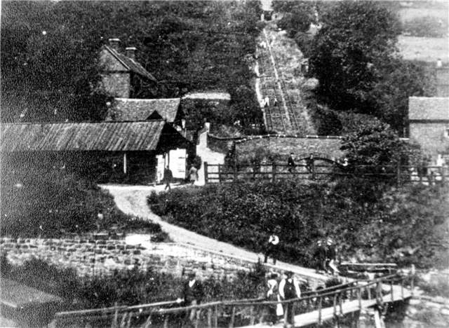
Archive images of the Hay Incline:

 1957

 1879

Source - Ironbridge Museum Archive


 1958

 1971

Operational Incline with  Jacksville Ferry


Severn Trow at Ironbridge


A rebuilt Spry in 1986 - Source - Ironbridge Gorge Museum Archive

The above photos have been assembled from various sources, including those freely found on the internet. My thanks go to the many photographers alive and dead who have contributed to this collection and in so doing, are keeping the memory of these  canals alive. These images are reproduced for ease of research are are not necessarily the property of this blog and some may still be subject to copyright, and as such they should not be used for commercial gain without the explicit permission of the owner (whoever that may be). 

Sunday, 3 April 2011

Hay Inclined Plane

Hay Inclined Plane
Blist Hill Nr Ironbridge
April 2011

Whilst the network of tub boat canals which connected Shrewsbury with Ironbridge may have been largely lock free, they did have to traverse some hilly topography and through an area with very little  surface water.

Hay Inclined Plane

The answer was the development of the inclined plane, or put another way, railway tracks up a hill which carried either a water filled cassion in which a boat floated or, at Blist Hill, a cradle which carried individual tub boats.


This area turned the inclined plane into  something of an art form, with four of them in the vicinity. The Hay Inclined plane is the only one which survives, set at the southern tip of the Blist Hill Museum site. The slope carried tubs down over 200ft to the Coalport Canal below, and then into the River Severn.

Top of Hay Inclined Plane

This plane is in good repair, offering a good idea of how it looked in its heyday. True the main rails have been replaced with incongruous BR cast offs, but their placement does offer a sense of scale and proportion to the location. For the purists (and I had two serious rail buffs with me) a close examination of the slop into the canal bed at the top revealed original cast iron rails.


Most of the energy used to move the tubs will have been by gravity, but the remains of a boiler house remains which was used to help when needed.

Some inclined planes were short lived and unsuccessful, like that at Foxton on the GU Leicester Line, but this one was a big success - operating for over 100 years between 1792 and 1894.

Trench Inclined Plane

The other notable inclined plane on the system was at Trench, near Newport. This operated commercially till the canal closed in the 1930's. This was lost under the Telford sprawl, which is what has happened to most of this remarkable network.

On surprising feature of the site is the remarkably tight turning space at the top of the lift. To one familiar with the dynamics of a narrowoat it seems impossibly short, but the tubs were only about 20ft long and carried a 5 ton load, so didn't need a lot of space.

This location offers a rare opportunity to see an inclined plane layout, all preserved as a scheduled ancient monument.

Sunday, 2 February 2014

Combe Hay - upper section

Combe Hay - the top end
February 2014


Combe Hay has a lot to offer the canal enthusiast and justifies a lingering approach, savouring the great remains which are there to be enjoyed.  


Comb Hay top lock and channel to inclined plane / pumping engine


I spent a very enjoyable couple of hours exploring all the sections of the Combe Hay area I could legally access, and a few where legal rights of way had to be viewed as a somewhat elastic concept. What I didn't feel I could do in all conscience, was to go blunderimg around the sites of locks three to eight which are clearly in the grounds of Caisson House and were well protected by barbed wire, indicating that casual visitors are not welcomed.

Given the material to be covered I will divide the Combe Hay reports into three, the upper section (this post), the middle section containing the thick of locks and the lower section which includes the buried/ less restored locks plus the channel to the base of the inclined plane.

Most canals seem to have something unique about them and for the SCC, its USP undoubtedly lies in its varied attempts to climb 135 feet from the Kennet and Avon level to the summit pound. 

Attempt one - The Caisson Lock
The canal builders were working to a budget and wanted to avoid the cost of a long flight of locks. They therefore cast around to alternatives and settled on the untried Caisson Lock concept. This was the brainchild of Robert Weldon and to give its his full title it was the Hydrostatick Caisson Lock. He had made a working model for the tub boat canals in Oakengates, beneath what is now Telford, but its interesting to note that he was never daft enough to actually try and make it work, even for their small 5 ton tubs.

Design for Caisson Lock as found on the SCC website

To be honest you need to see a drawing of this idea, which is explained very thoroughly in the SCC website.

But put simply, they decided to build three super deep locks which would never actually empty. Instead the canal boat would be put into a wooden "submarine" a bit like a torpedo in its tube, and the whole assembly would then be sunk with the boat floating inside. When it reached the bottom the end would lock into a watertight seal and the door opened letting it float out and away.

Fast, quick and uses almost no water. Perfect, fantastic and great - lets order 1000! Oh, but before you do, listen to that nagging word of caution in the back of your head. Its telling you that it sounds like a disaster waiting to happen and so it was. The builder managed to get the top one working and for some reason known only to themselves the SCC Committee decided to take a ride in it. Of course the inevitable happened and it became stuck and the committee was very nearly suffocated before the water was drained off and the caisson opened. Needless to say this was enough to see the whole project abandoned in or around 1794.

Attempt two - The inclined Plane
I suspect that the SCC Committee had contact with the Duke of Sutherland and his canal network at Lilleshall. Not only had the ill fated Caisson Lock come from their operation, they also made extensive use of inclined planes. The SCC therefore installed three locks at the foot of the site and then an inclined plane to raise the boats about 110ft.

Navigable feeder from Pumping Engine

This system was made to work and the long approach channels can still be found and top and bottom. For the purposes of this post we will look at the upper channel which curves around Caisson House and follows the contour round the hill to the site of the old Pumping Engine.

It would appear that the top of the inclined plane was somewhere very close to where Caisson House stands today, but the feeder channel to the Pumping engine was not only a water channel but also a way of getting coal to its boilers.

Remains of the pumping engine

Today the dry channel is apparent and the foundation of the pump house remains to be viewed.

The lifespan of the inclined plane was short, probably less than 10 years, and my guess is that like so many other inclined plane ventures, it failed do the unreliability of the technology with buckling tracks and the cost of maintaining steam in the winding engine. Similar inclines worked well on the Shropshire Canal but these only carried tubs weighing about 5 tons plus cradle, whereas the Combe Hay versions would be carrying 28 tons of loaded craft plus water filled tank and cradle. Even 100 years later in 1900 a similar plan was implemented at Foxton, but this was also abandoned in after a few years in favour of conventional locks.

Attempt three - the 22 Locks
Within a few years the inclined plane was abandoned and by 1804 the funds had been raised to build a flight of conventional locks - the same ones we see today.
A special act of Parliament was needed for the Lock Fund and the end result was a flight which was rugged and almost northern in quality - big blocks of stone all over the place. I bet they were dreadful pi##ers! 
One odd feature of these locks was their narrowness. They were built to carry narrow craft which when strapped together fitted the Kennet and Avon locks. As a result they were built to a width of about 6ft 8in.


 Lock 1 of the Combe Hay flight


From the top at the entrance to Caisson House you can wander around the top lock and see lock No2, its leaning sides held apart with tree trunks and remnants of sagging lock gates - like a surreal Salvador Dali painting.

Lock No 2 - Combe Hay

An old map of the Combe Hay site taken from the SCC website.

I have to acknowledge the SCC website which is a veritable treasure trove of history and which I have used to provide a superficial overview of the area. I would urge you to visit their site for a much fuller history.

Monday, 5 March 2012

Shropshire Canal - Wrockwardine

Shropshire Canal
Wrockwardine Wood
March 2012

Other Posts in this Shropshire Canal series:


1. Wrockwardine Wood (this post)
2. Central Section - modern Telford
3. Radlay Reservoir
4. Stirchley
5. Aqueduct 
6. Madeley
7. Blist Hill
8. Hay Inclined Plane
9. Coalport


Finally, after two hard days of walking the line of the northern section of this long lost network of Tub Boat Canals we can turn south and start the eight mile trek to the River Severn, taking in a couple of detours along the Ketley Canal and Horseferry Branch as we go.

Shropshire Canal north of Telford 2012

Northern Worckwardine Wood 1902

Having completed the Wombridge Canal and also its sister the Ketley Canal just to the south, William Reynolds decided to connect the whole thing up in 1792. Like us, he returned to the junction between the Wombridge and the Donnington Wood Canal at Wrockwardine Wood as a starting point.

Wrockwardine Inclined Plane


Wrockwardine Incline 1967


During our last visit to the site I mistakenly assumed that the Wrockwardine Inclined Plane ran up the path beside the Methodist Chapel. Whilst this looks a likely route it is slightly off and the foot of the plane was reached by a short arm which extended to somewhere under the road embankment which has covered the site. Just beyond this road the plane emerges as a perfectly straight and graded incline running for an impressive 316 yards into the trees at the top of the escarpment 113ft 2" above us.


Top of Wrockwardine Inclined Plane and the canal bed leading away to the south

This plane operated with a "hump" at the top over which the boat cradles were hauled by steam engine, and set into the pound beyond. This earth bank remains and with a  bit of imagination and a sprinkling of snow you can still see the shallow depression which contained the canal till it ceased operating in the 1830's. The initial days of this plane were troubled, with subsidence causing a crack 3" wide in the floor of the engine house in 1795, a forerunner of what was in store for the rest of the canal as the years and mines progressed.


Shropshire Canal in Wrockwardine Wood

The site also contains an unusual wall near the top of the incline and it would be nice to make it part of the structure built over 200 years ago, but sadly this is probably nothing more than a later boundary wall. However, careful inspection of the plane route itself does reveal a robust brick wall which is probably an original  retaining wall on the northern edge


Shropshire Canal in the back gardens

The most frustrating thing about this particular canal hunt is the lack of photographic records of it in operation. We have images of the Trench section which continued till the 1920's, but these other sections were abandoned in the first half of the 1800's, and photography only emerged in the 1830's and even then the new and expensive technology wasn't to be wasted on a utilitatian transportation system. So that leaves us with a handful of descriptions and some fragments on the ground, plus some maps and our imaginations which is all we need really!


Southern Wrockwardine Wood 1902


Canal emerging from the gardens and running alongside the Silkin Way

The northern extremity of the Shropshire Canal skirts round the western edge of Wrockwardine Wood, now a pleasant place to walk but wind back 150 years and the place was riddled with mines shafts and spoil heaps covering the whole area. Initially the line of the canal is clear in a trench before it becomes covered by the gardens behind the houses which skirt the woodland. Footpaths cross the line at several points, which eventually becomes part of the Silkin Way, a long distance path which follows the line of the canal quite closely all the way to Blist Hill. This section can we covered on foot but given the well maintained path it would be equally suited to a cycle expedition.


Last remains of Shropshire Canal emerging from Wrockwardine Wood

At times the trench is visible alongside the path but in other places mining has thrown great piles of debris across the canal bed. These tips are apparent on the 1902 map near Oakengates and remain in situ today, although the remnants of water shown 100 years ago are long gone and we are now left with a dry depression which hugs the countour and provides excellent views out over the Shropshire plain a couple of hundred of feet below us. Such a contrast to the smoky hell hole this place must have once been.

The above photos have been assembled from various sources, including those freely found on the internet. My thanks go to the many photographers alive and dead who have contributed to this collection and in so doing, are keeping the memory of these  canals alive. These images are reproduced for ease of research are are not necessarily the property of this blog and some may still be subject to copyright, and as such they should not be used for commercial gain without the explicit permission of the owner (whoever that may be). 

Thursday, 27 October 2011

Mapping out Telford's Tub Boat Canals

The Tub Boat Canals of Telford
October 2011

My decision to follow the lines of Telford's tub boat canals was never going to be easy. In fact I think its going to be my toughest lost canal challenge yet.

It has been said that there is coal at the heel of ever successful canal, and nowhere is this more true than among the tub boat canal network of what has since become Telford. This is the site of the Coalbrookdale coalfield, a small geographic site about eight miles long and three miles wide through which a fault line travels with shallow coal to the west and deep coal to the east. The area was also blessed with Ironstone, limestone and clay - a perfect mix for iron and pottery works.

This hilly site was largely devoid of surface water so the early canal builders had to use inclined planes to lift and lower boats in a mainly lockless and self contained system, whose primary outlet was the river Severn to the south. This little network flourished for about 50 years after its construction in the late 1700's but the effects of mining, a chronic shortage of water and unreliable planes resulted the area enthusiastically embracing railways as a cheaper and more flexible alternative. 

The majority of the canal network was therefore lost by 1850, buried beneath spoil tips and railway lines. To add to the canal hunters misery, the area continued to be deep mined and industrialised well into the 20th century, before falling into something of a post industrial wilderness till the 1960's. Then, as icing on the cake, the entire coalfield area was designated a newtown site and the waste tips graded over, industry leveled and redundant railways turned unto roads along the lines of Milton Keynes. All this change over a period of 150 years scrubbed out most evidence of the little network of waterways, especially in the central section. But look a little further afield and telltale traces can still be found.

The place to start is with maps of the area as it used to be - working out the evolution and decline of each section. This can then be plotted on a contemporary OS map using known landmarks and core road layouts, which have survived even the reconstruction of Telford. As in decorating, 80% of the effort should be spent on research with the time in the field being very focused and targeted. Its a good job that the desktop research is an interesting task in istelf!

So before I forget what I have learned, here is the sequence of development of the tub boat canals of what is more properly referred to as the Coalbrookdale Coalfield.

Stage one:
Donnington Wood Canal (or Marquis of Stafford's Canal)
The initial section was five miles long built in 1768 from Donnington Wood to Pave Lane, the Wolverhampton Turnpike. A later branch canal was created at Lillishall featuring a 70ft inclined plane and seven locks which operated till 1878/9 at which time both the branch and mainline beyond this point were abandoned. A further section was lost near Lillishall Hall in 1890 when a driveway was laid across its path with the rest becoming disused by 1904 when the mineral line look over the trade. The watercourse dried out in 1928 when the the mine pumping engines were turned off. This was always a shallow canal, even by tub boat standards, carrying a mere three tons per boat.


Stage two:
Wombridge Canal 1788 
One and a half lockless miles long, built by William Reynolds to move surface coal from Wombridge to his furnaces at Donnington Wood and its junction with the Donnington Wood Canal. Having exhausted most of the minerals at Wombridge he sold a mile of the canal to The Shrewsbury Canal Company in 1793. The Shrewsbury Canal Company built the Trench Inclined Plane and so created a connection through to Shrewsbury. The remnant continued as a branch canal for nearly a century to Bullocks Mill and closed completely in 1921.


Ketley Canal
At the same time Reynolds was working on the Wombridge Canal, he also started to think about transporting coal and ironstone from Oakengates to his works at Ketley, a couple of miles to the south of Wombridge. This canal was also begun in 1788 but incorporated the UK's first Inclined plane at Ketley Hall, dropping the tub boats down 73 feet to Ketley Ironworks.
The plane was found to be disused by 1818 and it is likely that by then the entire canal had ceased to function by 1816.


Stage three:
The Shropshire Canal
This was the final element of the local canal system, linking the Donnington Wood Canal to the north with the River Severn in the south.


The terrain dictated three inclined planes:
  
Wrockwardine Wood - 120 feet high and 320 yards in length.
Windmill - 600 yards long
Hay - 3/4 mile long


This line also featured a branch at Dawley to Coalbrookdale which was dry by 1825 with the main line converted to a railway in 1860. The final stretch at Blist Hill remained in use till 1912.


The above photos have been assembled from various sources, including those freely found on the internet. My thanks go to the many photographers alive and dead who have contributed to this collection and in so doing, are keeping the memory of these  canals alive. These images are reproduced for ease of research are are not necessarily the property of this blog and some may still be subject to copyright, and as such they should not be used for commercial gain without the explicit permission of the owner (whoever that may be). 


Monday, 26 March 2012

Shropshire Canal South - Madeley

Shropshire Canal South
Windmill Incline to Madeley
March 2012


Other posts in this series:


1. Windmill Incline to Madeley (this post)
2. Blist Hill
3. Hay Inclined Plane
4. Coalport

Returning to the Horsehay Branch near Aqueduct the remains of the canal track are few and far between and the best you can do is to try and follow the contours. Even this limited objective is complicated in the area called Brookside (yes, it actually looks like TV's Brookside) which has built up on the site of the old Windmill Inclined Plane. The area was the site of a huge coal mine and the whole area seems to have been used as a tailings dump. 


Even in 1902 the traces of the canal were fragments and the line could only be deduced by inference. As far as I can tell, the top of the incline is near the south side of Windmill School and descended just 125 ft in 600 yards so it was a long and gradual descent from the school, through the dual carriageway and on into Tweedale and having its base around the entrance to the Severn Gorge Caravan Park and the Cuckoo Oak Pub before crossing the Bridgnorth Road and through the Tweedale Industrial Estate.


Bottom of Windmill Incline crossing the Bridgnorth Road


Through Tweedale industrial Estate


and out along a strip of old towpath to Prince Street


Although no traces of canal remain in this area, its line can be followed as a public path on a strip of wild ground between Tweedale Industrial Estate and Prince Street before crossing Kemberton Road / Queens St and probably running down the eastern side of a railway embankment which follows a similar southerly course.


Course of canal emerged from these trees in Madeley


Shropshire Canal bed in Madeley

Getting wetter...

and wider...

End of canal at Blist Hill

The track is indistinct on the ground but the maps are clears that it ran south into Madeley. This popular park is criss crossed with cycle ways and the canal re emerges next to Sutton Way, first as an intermittent dry ditch, and then increasingly in water as we approach Blist Hill and the site of the Madeley Brick and Tile Works which is now the museum overflow car park.


Through the museum overflow car park.

Tub Boats on Shropshire Canal at Tweedale with Madley Furnaces behind  - Source Ironbridge Museum Archive


The above photos have been assembled from various sources, including those freely found on the internet. My thanks go to the many photographers alive and dead who have contributed to this collection and in so doing, are keeping the memory of these  canals alive. These images are reproduced for ease of research are are not necessarily the property of this blog and some may still be subject to copyright, and as such they should not be used for commercial gain without the explicit permission of the owner (whoever that may be).