Thursday, 5 February 2009

Lichfield and Hatherton Restoration Trust

15 minutes of fame

I get plenty of public exposure within my day job, but not so much in respect on my rather nerdy interest (obsession?) in canals. Belle would undoubtedly say that that is a good thing, and she is probably right!

I was amused to receive the winter edition of Cut Both Ways, the Lichfield and Hatherton Canals Restoration Trust's newsletter. I perused the contents and there in the centrefold was a picture of your truly being formally welcomed in as the 2,000th member by Brian Kingshott, the Chairman.

I suspect that this is the first and last time I will be a centrefold, and I didn't even have to take my clothes off...... I am such a classy act you see.


Having overcome my surprise it was slightly saddening to read how the current economic troubles are impacting charities such as LHCRT, causing them to tighten their belts, reduce their short term ambitions, waiting for the return of more prosperous times. LHCRT has been operational for 20 years now and whilst much progress has been made, the "to do" list is as daunting as ever. Restoring rural canals is a long term activity and the primary qualifications for committee membership has to be patience and dogged perseverance.

The most salutary section of the magazine was the fact that of the ten who formed the original committee in 1988, five are no longer with us, three have moved on to other things and two stalwarts remain. Well done Brian and Eric - you deserve a medal apiece.

Monday, 2 February 2009

Cromford Canal - a short walk

Cromford Canal
Cromford Wharf to Whatstandwell
1st Feb 2009

Index of posts in this series:
1. Cromford to Whatstandwell - this post
2. Whatstandwell to Buckland Hollow Tunnel
3. Buckland Hollow Tunnel (Excavator Pub) to Ripley Bridge
4. Ripley Road Bridge to Butterley Tunnel (west portal)
5. Butterley Tunnel
6. Butterley to Ironville
7. Codnor Reservoir to Smotherfly (Pinxton Arm)
8. Smotherfly opencast section
9. Pinxton Wharf
10. Boat Inn at Pinxton
11. Ironville
12. Ironville to Erewash Meadows
13. Erewash Meadows to Langley Mill

A 9 mile return journey along the towpath, including the Nightingale / Lea Wood Arm


The narrow (7ft) Cromford Canal has a long and illustrious past, connecting Richard Arkwirght's Cromford Mill in the north with the Erewash's Langley Mill basin 16 miles away in the south.
The main section of the canal took five years to build and was opened in 1794, having cost twice as much as predicted. The waterway was an overnight financial success, paying the investors massive dividends and making it something of a Dot.com boom of the 19th century. The freight traffic was so heavy that the Butterley Tunnel was obliged to work 24 hours per day to cope - if you take a look at the waterway today it is difficult to visualise where the demand came from.


Whilst the trade in coal, coke and limestone was very good for many years, volumes halved between 1840 and 1843 when the High Peak Railway was completed. From that time on the canal was in decline, with trade down to a handful of boats in 1888 when the 3063 yard Butterley Tunnel suffered its first major collapse. It took 6 years to repair, only to see it collapse again in 1900. This time the closure was permanent cutting off the north west section of the Cromford Canal from the main system.


For most of its length beyond the Butterley Tunnel this lockless rural waterway has avoided the ravages of redevelopment but some blockages exist around Ambergate which will demand a creative approach if navigation is ever to be restored. Much work was undertaken by Cromford Canal Co Ltd, a charity which operated in the 1970's and 1980's and focused on the northern section, near Cromford Wharf. Whilst this body was wound up in the late 1980's, they delivered a lasting legacy of an excellent linear water park with a well made towpath which continues to have massive appeal with walkers and cyclists alike.


Well, that's a potted history of the north western section. With Tilly's school nearby the canal seemed an ideal destination for a winter walk, with the prospect of a pub lunch at the far end.
We set off with the thermometer hovering on zero and Siberian blizzards forecast, so our expectations were not high. We parked up opposite Arkwright's Mill, which is backed by the feeder into the canal. This car park is free, unlike the "official" car park at the wharf which will set you back about £3 for a 3 hours.

The extensive restoration work undertaken in the wharf area is a delight and provides a beautiful jewel for the current restoration project to work towards. To complete the scene, just add boats.


The well maintained towpath leads south past Railway End Bridge (Browns Bridge) which was the southern terminus of the High Peak Railway, constructed in 1831 to connect with the Peak Forest Canal in Whaley Bridge via a series of 3 inclined planes. A canal link was considered but rejected on the grounds of costs, locks and lack of water.


A little further on there is the impressive Lea Wood Pumping Station which was used to raise water from the River Derwent at a rate of 4 tons, three times a minute. The steam engine is still operated by volunteers who raise a head of steam and allow visitors free entry on bank holiday afternoons, belching smoke from its distinctive chimney.


Close on its heels is the Wigwell Aqueduct which carries the canal over the Derwent via a massive stone span with an inset iron trough, reminiscent of the Dundas aqueduct on the Kennett and Avon. The structure can't be viewed well from the towpath but a diversion along the Nightingale Arm and then down the steep bank to the rivers edge will be rewarded with a great view from a perfectly sited wooden bench.


The Nightingale Arm was a half mile private canal, built by Florence's father, to serve a range of quarries, lead works and cotton mills, continuing to be used long after the closure of the tunnel as a connection to the railway transhipment yard until it too was closed in 1936. The canal bed remains, but the trough carrying it over the High Peaks Railway has long since gone, leaving just an outline in the abutments.


The canal winds round the hillside before passing over the same railway line as it emerges from the southern end of its tunnel. The High Peak Aqueduct crossing is made by a short iron trough, which is now showing signs of age and had been dewatered at the time of our visit.


The canal continues to make it's way south, hugging the eastern slope of the Derwent valley till it encounters a high ridge through which the 200 yard Gregory Tunnel was built, emerging into a large, heavily reeded up lagoon.


Whilst the CCC Ltd's tour boat John Gray navigated the tunnel as recently as 1988, this is the end of meaningful navigation for anything but canoes. The bed gets progressively closer to surface and at times there depth is reduced to a few inches with obstacles obstructing even such shallow drafted craft. Land drains cascade silt into the canal bed, creating alluvial deltas which have to be periodically dredged to maintain the canals residual drainage function. However, silt is easy to clear and the canal bed remains in good shape.


Lunch was taken at the Derwent Inn at Whatstandwell, about an hour and a half south of Cromford Wharf. This pub serves large portions of Sunday Lunch for about £7.00, making it a popular destination for walkers.


The return journey was completed with snow laden skies gathering over our heads and the temperature dipping below zero. We just had time for a wander up the Nightingale Arm before returning to the car, four hours after we set off.


This is a spectacular stretch of canal with a well maintained towpath, ensuring a steady stream of visitors, albeit in two feet or two wheels rather than atop a marine diesel engine. Hopefully the work of the Friends of Cromford Canal will result in a complete restoration in due course, with navigation possible all the way to Cromford Wharf. The journey high up along the side of the Derwent valley is spectacular and could rival the Vale of Llangollen, minus the Poncycellete of course! The linking Erewash Canal isn't currently one of my favourites, with only it's last mile hinting at the boating possibilities which could one day lie beyond the 16 disused locks above Langley Mill.

A lack of time and energy prevented further exploration but, having sampled the first four miles, that means that there are another 12 miles left, plus the Pixton Arm which justifies at least three more visits. As if I need an excuse to poke around a waterway! 

Update 6.1.10: THree more visits, what a joke! I havenow been back on four more occasions and have only just reached PInxton. Ironville to Langley Mills remains unexplored.

Sunday, 25 January 2009

Market Weighton Canal

Market Weighton Canal
25th January 2009
Walking Tour

Market Weighton Canal - Where's that? I hear you ask.
Its a 9.5 mile canal of which six miles remain navigable, located about 10 miles west of Hull. It stretches north from the Humber Estuary across flat farmland ending just short of the town of Market Weighton.


This is a very obscure waterway which leads directly onto the Humber estuary and which hasn't had a right of navigation since 1971. That said, the channel is navigable and Weighton Lock (also known as Humber Lock) remains operable subject to prior consent of the EA.


The inaccessible nature of this waterway ensures that few boats will ever venture up its short length, although NB's Earnest and Frogmoore managed the feat in 2005. I can't see myself chancing my arm in Wand'ring Bark, so I decided to satisfy my curiosity with a walking inspection whilst visiting relatives in the area.


The 9.5 mile navigation was constructed in 1782 to drain the surrounding fields and this remained its primary purpose throughout its life. Indeed, its drainage function is the reason for its continued existence. It never quite reached Market Weighton, ending its run and Canal Head (not the most imaginative place name!). By 1900 the top 3.5 miles above Sod House Lock had been abandoned
losing Mills Lock and Holme Ings Lock in the process.This upper section is now largely in filled. A limited amount of brick carrying trade continued on the lower reach til the 1950's.

The lack of traffic on the canal resulted in a loss of the right of passage in 1971 and shortly thereafter Weighton Lock was threatened with closure, only to be saved by a local action group who managed to have it noted as a listed monument, thus ensuring its continued existence.

The canal is navigable to just below the remains of Sod House Lock and a winding point is in the mouth of the Foulness River, which is itself potentially navigable for several miles when weed conditions and water depth permit. All in all this is a navigable drain very reminiscent of the drains in and around Boston - dead straight with pumping stations and very high banks.


With no vessels on the waterway there are no facilities and even mooring near Newport (the only village on its route) looks tricky.

As I said, not a canal I ever expect to navigate, even in a canoe, but it is an ancient structure which justified a visit on a blustery January morning.


My apologies for the mixed qualities of the photos. The grainy ones were courtesy of my Blackberry and the decent springtime ones were courtesy of the local Drainage Board website and the TNC's encyclopedic photo archive.

Sunday, 18 January 2009

Fred (Dibnah)

Book Review Fred by David Hall


Whilst the biography of Fred Dibnah isn't really a waterways book, his fascination with all things industrial revolution makes is a worthwhile read for canal enthusiasts. Furthermore, he was an active canal enthusiast in the Burnley / Manchester area and a great advocate for restoration, so I am allowing his book into the "waterways" section of my library.

Fred feels like a permanent fixture in my life, with vivid imaged of the early series "Fred Dibnah, Steeplejack" an essential part of my adolescence. The book takes a candid look at his life and passions with a particular bias towards his developing role of TV presenter. This bias is understandable as the author, David Hall, was his producer for many years and was therefore particularly well placed to observe this aspect of his persona.

The book tracks his life from an under performing student in Burnley, through his joinery and steeple jacking career and finally into his TV presenting role, whilst all the time following the ever expanding living museum in his back garden and the gradual restoration of his two steam engines, not to mention the replica coal mine!

Fred comes across as a man utterly obsessed with the Victorian era and steam power. So obsessed that his family life and his finances suffered and, just as stability arrived in his later years, his health failed, robbing us of one of England's finest characters.

The book contains many direct quotes and it is impossible not to hear his Burnley accent booming out of the pages. An absorbing read for those this a passion for the industrial revolution.

ISBN 0 - 593 - 05664 - 7

Sunday, 11 January 2009

Ice Breaking on Staffs and Worcester

Ice Breaking at Four Ashes
10th Jan 2009

It's always good to get the first run of the season under ones belt.

I have plans to try and document the waterways journeys I took with the Captain Snr, Matilda and sometimes my brother during the late 1960's and 1970's. These plans moved one step closer this weekend with an overnight stay on Wand'ring Bark with my brother, who was part of the crew on the earlier trips. Our plan was to take the boat to Penkridge, have a pub meal and then spend the evening sorting through the many boating transparency slides taken between 1967 and 1979.


The weekend had been scheduled in the diary for months, so a little bit of frost wasn't about to put us off. We arrived at Calf Heath to find WB covered in rhyme and the marina covered in a thick layer of solid looking ice. However, an inspection of the cut at the junction with the Hatherton Canal gave some hope, it was ice free.

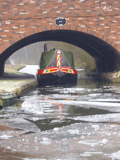
We got the stove going and, after a bit of effort, eased WB out of the marina. Our initial optimism was dashed when we turned the first corner and were confronted by a solid sheet of ice which stretched from bank to bank. Never mind, "I'm sure it will clear up soon" I said as we crunched into the ice floes. Predictably, things didn't clear up and is was soon apparent that we wern't going anywhere near Penkridge, not even Gailey for that matter! We quickly revised our ambitions and decided to make for the winding hole at Calf Heath bridge, alongside the Four Ashes chemical works. Even this turned out to be a challenging target, but by the time we had moved a mile we didn't fancy stern hauling the boat all the way back!

The ice got thicker and thicker, with the boat grinding its way along and chunks of ice skittering away from our bow. We finally made it to the winding hole and thankfully, the water under the bridge was ice free, which gave us some room to rope the boat round for the return trip. Rather than face the ignominy of a quick return (we had acquired quite an audience on our departure) we stopped for lunch, warming our numb fingers and watching the local model aeroplane club test a model jet. I had never seen a remote controlled jet before and the high minimum speed made for a very interesting landing. After a lazy lunch and much catching up we made easy passage back through the path we had cut, returning to our berth as the sun faded at 3.30pm. Don't even think about the blacking on the bows..... what blacking?


Our plans for a pub meal evolved into drive to the Fox and Anchor at Coven, where we secured a prime fireside spot and whiled away a couple of hours, only to return to the car and discover that thieves had smashed the side window, trying to steal a non existent Sat Nav and ipod in the glove compartment. Great.

After a chilly trip back we attacked the old photos, sorting them into chronological order on a light box my brother had purloined from a hospital. The slides were rarely labelled and at best they had a cryptic caption like "leaving a lock near Birmingham" - thanks Captain Snr!. However, we applied ourselves to the task sorting them initially by boat and then, by looking at the backdrops and searching our combined memories, we managed to piece together the likely routes we had followed. Finally, we tried to put them into a timeline based on the ever maturing face of yours truly (I was seven when we started). In the end it was rather like a jigsaw of our past - thoroughly enjoyable for us but totally boring to anyone else.

Neither of us have been very good and recording our pasts ,and this exercise proved the benefits photographic records. They provided memory triggers of things in the past, events which should be remembered. In spite of a clutch of degrees and diplomas between us, we found evidence of trips we had completely forgotten, and photos of friends and families that had joined us, many of whom are either dead or forgotten. The moral of this story is; don't throw out your old slides or prints - stick them in a box because you never know who may want to rake over the past in 40 years time!

The next step is to convert these faded images into a digital format which will then persist in glorious sepia for ever. When this task is complete I will publish the photos in the blog, preserving the past on line in case my hard drive fails.

We settled down for a good nights sleep at 1.00am, with the stove warding off the frost. Interestingly, the on board thermometer indicated that the air temperature inside the boat dropped to minus 8 during the week, testing the integrity of the pipes and anti freeze to the limit.