April 2020
The line of the canal become very indistinct after the village of Norton Canes, making a brief appearance east Badger Bridge where a quarter of a mile of canal bed is still to be found at the bottom of a garden, and then disappearing beneath the massive area of ground which was opencast mined by the NCB.
The surface layer has been completely stripped away and the coal was removed in the 1960's and 1970's, and the landscape re-profiled in the 1980's. Today much of it is either open space or covered in light industry and retail parks, and whilst you can follow the path on a map, its anyone's guess what the levels used to look like!
Over the years I have found photos of most of the bridges and structures, but getting the sequence right in an area which has been so radically reshaped has proved to be very challenging. I cant really claim all the credit for the following sequence of photos which, to the best of my knowledge, reflect the order you would have encountered them when traveling from the south to the terminus at Hednesford. I have been fortunate to have had the help of a group of local residents and a few boaters who were on the last trip in 1962, and who remember the canal in water. Mention also has to go to Duncan Moore, who has at times persevered in this effort when I started to despair.
If you have any missing images, please let me know and I will add them to the sequence.
If you have any missing images, please let me know and I will add them to the sequence.
My apologies for the length of this post - many more images have surfaced over the years and it seems a shame not to include them!
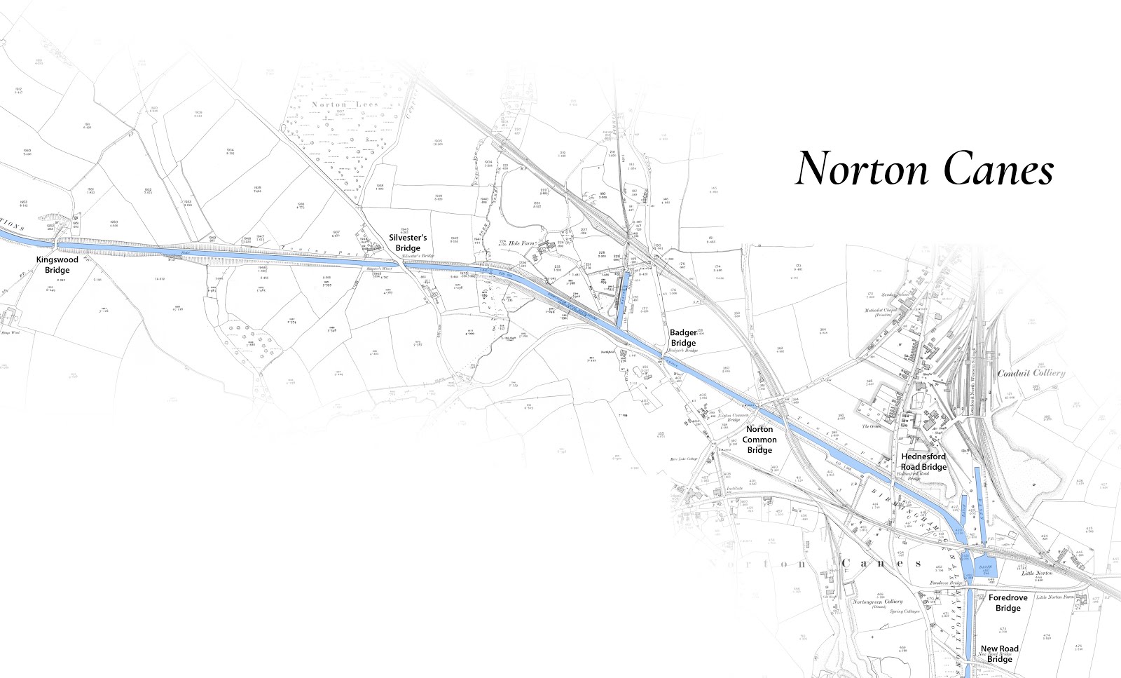
Norton Canes area

An arial view from above Conduit Colliery towards Rumer Hill Junction


Looking south to Foredrove Bridge with the subsided Conduit Basin on the left


Conduit (aka Norton Springs Branch) entrance before subsidence

Looking north west towards Hednesford Road Bridge - John Whitehouse

Courtest of Canal and River Trust's National Waterways Archive

Hednesford Road Bridge (at the top of the rise)


Aerial view of canal from Hednesford Road Bridge to Kingswood Bridge


Looking west from Hednesford Road Bridge to Railway Bridge 1915


As above, but closer to the railway bridge and viewed from the towpath side

Judith Anne and Dart double heading in the winter of 1948


Leonard Lee's Joan towing five day boats - location unidentified - BCNS Archive

Railway and Hednesford Road Bridge viewed from Norton Common Bridge looking east

Courtesy of Canal and River Trust's National Waterways Archive

Looking west to Norton Common Bridge


Courtesy of Canal and River Trust's National Waterways Archive

Badgers Bridge looking east

Courtesy of Canal and River Trust's National Waterways Archive

Courtesy of Canal and River Trust's National Waterways Archive

Courtesy of Canal and River Trust's National Waterways Archive


Badgers Bridge is in the middle of this image - the eastern edge of the Poplars Opencast site

Coppice Colliery Basin


Courtesy of Canal and River Trust's National Waterways Archive


Silvesters Bridge looking west


Puddling repaired banks at Silvesters Bridge 1950's


Courtesy of Canal and River Trust's National Waterways Archive

A later (repaired) Silvesters Bridge looking east (Hugh Potter)

East from Silvesters Bridge 1950's


Silvesters Wharf looking west from Silvesters Bridge (Tony Manning)

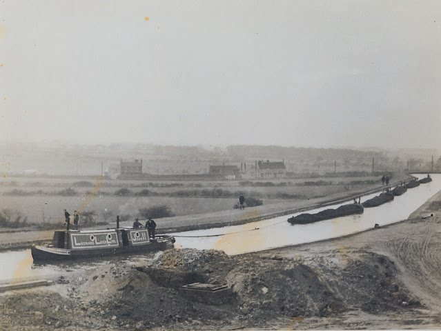
Working Boats on the Cannock Extension Canal 1950's

Norton Lane crossing Sylvester Bridge

Sylvester's Wharf looking west after dewatering


Rumour Hill to Hednesford

Poplars Opencast looking north at Rumer Hill Junction with A5 in foreground


Courtesy of Canal and River Trust's National Waterways Archive

Kingswood Bridge October 1962 H E Evans
Courtesy of Canal and River Trust's National Waterways Archive

Kingswood Bridge looking east into cutting (Hugh Potter)


Courtesy of Canal and River Trust's National Waterways Archive

Courtesy of Canal and River Trust's National Waterways Archive

Looking west between Kingswood Bridge and High Bridge 1962

Photo HNBC Philip Weaver Collection
Dated 1963
Gang building up banks - subsidence
Photo taken looking south from High Bridge just south of Rumer Hill Junction.
On left, side bridge is entrance to Cannock and Leacroft colliery basin.
1963 - land was sinking so fast they could hardly raise banks quickly enough to keep pace. Dropped 15ft in a fortnight


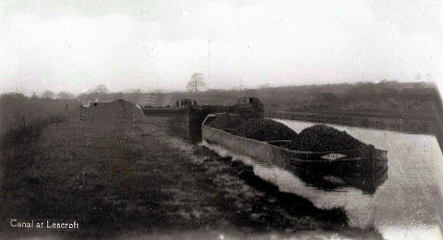
Leacroft Basin
The Cannock and Leacroft Colliery Co gained approval to lease the land to build this basin from the BCN committee in 1900 at a cost of £10 per annum.


Courtesy of Canal and River Trust's National Waterways Archive


Tramway bridge at Leacroft Old Hall Farm, just above the basin

Courtesy of Canal and River Trust's National Waterways Archive


High Bridge Bridge

Courtesy of Canal and River Trust's National Waterways Archive

Courtesy of Canal and River Trust's National Waterways Archive

Courtesy of Canal and River Trust's National Waterways Archive

Courtesy of Canal and River Trust's National Waterways Archive

Rumer Hill Junction from High Bridge Bridge (Tony Manning)

Courtesy of Canal and River Trust's National Waterways Archive

Courtesy of Canal and River Trust's National Waterways Archive

Courtesy of Canal and River Trust's National Waterways Archive

Churchbridge Top Lock at Rumer Hill Junction in late 1962? with opencast beyond - Source unknown


Rumer Hill junction

Courtesy of Canal and River Trust's National Waterways Archive

Opencast at Rumer Hill looking south

Rumer Hill Bridge in the distance looking north

Courtesy of Canal and River Trust's National Waterways Archive

Description: Dave Bailey from the Old Photos from Hednesford... group remembers the ropeway at Rumer Hill, and even rode it! "The basin with the overhead cables is Mid Cannock basin by Rumer Hill bridge. The small railway ran from Mid Cannock Pit and at some time loaded coal onto barges, it was not in use in the 50s, where it went under the road near the pit had been filled in.They did however leave a couple of coal tubs on the canal side and it was a gentle slope down to the pit end. We were able to push these tubes back up the slope and ride down in them, jumping of onto the grass bank before they hit the stop... The overhead cableway ran from Mid Cannock pit and the slag heap was on the far side of the canal, it was always on fire and had to be continually sprayed with water to damp it down. The steel nets under the cables protected people below from anything falling out of the overhead tubs. As kids we used to climb the gantries walk on the nets, jump up and grab a tub and ride across the canal, when I think back now it's a miracle we survived. I can't thank you enough for this picture it brings back so may memories of my childhood, what a playground we had."


Poplars Opencast looking over site of Rumer Hill Junction to Hednesford

Leacroft Bridge looking north 1962

Courtesy of Canal and River Trust's National Waterways Archive

Leacroft Bridge

Courtesy of Canal and River Trust's National Waterways Archive


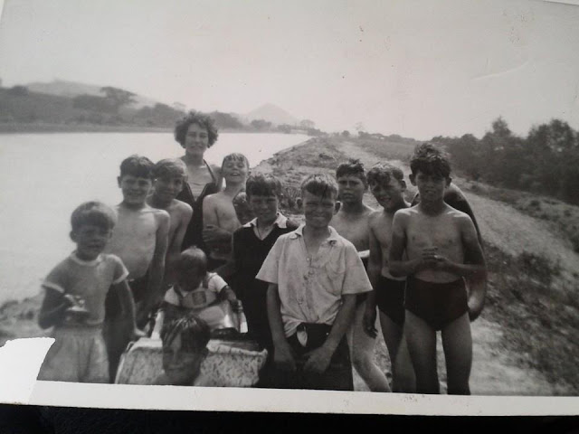
Salvation Army Sunday School outing neat Leacroft 1940's

Same Sunday School outing at Norton Pool (AKA Chasewater Reservoir) 1940's

Parkes Bridge and embankment looking south

A cropped in version

Parkes Bridge 1920 looking south


Hawkes Green Weir to the north of Parkes Bridge 1974 (Hugh Potter)


Courtesy of Canal and River Trust's National Waterways Archive

Under Hawkes Aqueduct


Hemlocks Farm - Deavalls Collection / Bob Williams


Hawkes Green Lane Embankment looking north

Hawkes Green 1945 looking north to to L&NWR Bridge

L&NWR Bridge looking north to Hednesford Basin

Courtesy of Canal and River Trust's National Waterways Archive

Boatmen's Mission between railway and Hemlocks Bridge


Looking south from Hemlocks Bridge with Boatman's mission on right

South from Hemlocks Bridge to L&NWR Bridge

Courtesy of Canal and River Trust's National Waterways Archive

Hemlocks Bridge entering Hednesford Basin 1962
The above photos have been assembled from various sources, including those freely found on the internet. My thanks go to the many photographers alive and dead who have contributed to this collection and in so doing, are keeping the memory of these lost canals alive. These images are reproduced for ease of research are are not necessarily the property of this blog, and as such should not be used for commercial gain without the explicit permission of the owner (whoever that may be).
3 comments:
I think the two shots around Silvester's bridge are the same shot, one in water, one drained. Also, the one you've got marked as maybe Hednesford Road bridge you also have marked as Rumer Hill Bridge. The idea that it's Rumer Hill bridge came from a sort of photostream I saw on the Norton Canes History Group on FB. (Sorry if I posted this twice, was doing strange things on my phone so I tried again on the desktop)
Duncan - would you believe it - I noticed that conflict yesterday and removed it. Its far more likely to be Rumer Hill than Hednesford having look at the shape on the aerial images.
Sylvesters Bridge remains outstanding in this collection!
Post a Comment